You are here: Home > Network List > CI - Caltech Regional Seismic Network Stations List
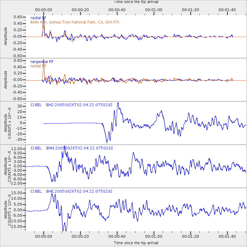
> Station BEL Belle Mtn, Joshua Tree National Park, CA, USA > Earthquake Result Viewer
BEL Belle Mtn, Joshua Tree National Park, CA, USA - Earthquake Result Viewer
| Earthquake location: |
Northern Peru |
| Earthquake latitude/longitude: |
-5.7/-76.4 |
| Earthquake time(UTC): |
2005/09/26 (269) 01:55:37 GMT |
| Earthquake Depth: |
115 km |
| Earthquake Magnitude: |
6.7 MB, 7.5 MW, 7.5 MW |
| Earthquake Catalog/Contributor: |
WHDF/NEIC |
|
| Network: |
CI Caltech Regional Seismic Network |
| Station: |
BEL Belle Mtn, Joshua Tree National Park, CA, USA |
| Lat/Lon: |
34.00 N/116.00 W |
| Elevation: |
1388 m |
|
| Distance: |
54.4 deg |
| Az: |
319.354 deg |
| Baz: |
128.714 deg |
| Ray Param: |
0.065122485 |
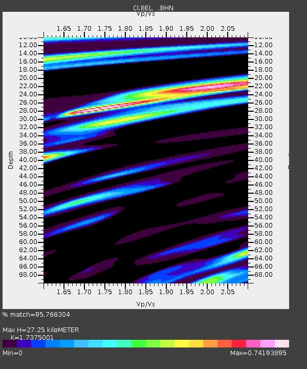
| Estimated Moho Depth: |
27.25 km |
| Estimated Crust Vp/Vs: |
1.74 |
| Assumed Crust Vp: |
6.276 km/s |
| Estimated Crust Vs: |
3.612 km/s |
| Estimated Crust Poisson's Ratio: |
0.25 |
|
| Radial Match: |
95.766304 % |
| Radial Bump: |
400 |
| Transverse Match: |
90.00974 % |
| Transverse Bump: |
400 |
| SOD ConfigId: |
2564 |
| Insert Time: |
2010-03-05 20:39:44.359 +0000 |
| GWidth: |
2.5 |
| Max Bumps: |
400 |
| Tol: |
0.001 |
|
Signal To Noise
| Channel | StoN | STA | LTA |
| CI:BEL: :BHN:20050926T02:04:22.075029Z | 26.611547 | 4.318097E-6 | 1.6226404E-7 |
| CI:BEL: :BHE:20050926T02:04:22.075029Z | 26.131039 | 6.176239E-6 | 2.3635644E-7 |
| CI:BEL: :BHZ:20050926T02:04:22.075029Z | 50.55741 | 1.4543865E-5 | 2.876703E-7 |
| Arrivals |
| Ps | 3.4 SECOND |
| PpPs | 11 SECOND |
| PsPs/PpSs | 15 SECOND |


