You are here: Home > Network List > CI - Caltech Regional Seismic Network Stations List
> Station BEL Belle Mtn, Joshua Tree National Park, CA, USA > Earthquake Result Viewer
BEL Belle Mtn, Joshua Tree National Park, CA, USA - Earthquake Result Viewer
| Earthquake location: |
Vanuatu Islands |
| Earthquake latitude/longitude: |
-14.3/167.3 |
| Earthquake time(UTC): |
2005/02/08 (039) 14:48:21 GMT |
| Earthquake Depth: |
206 km |
| Earthquake Magnitude: |
6.1 MB, 6.8 MW, 6.7 MW |
| Earthquake Catalog/Contributor: |
WHDF/NEIC |
|
| Network: |
CI Caltech Regional Seismic Network |
| Station: |
BEL Belle Mtn, Joshua Tree National Park, CA, USA |
| Lat/Lon: |
34.00 N/116.00 W |
| Elevation: |
1388 m |
|
| Distance: |
87.2 deg |
| Az: |
54.055 deg |
| Baz: |
250.89 deg |
| Ray Param: |
0.043003496 |
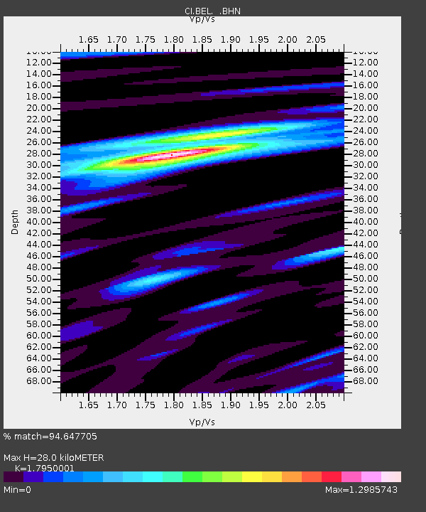
| Estimated Moho Depth: |
28.0 km |
| Estimated Crust Vp/Vs: |
1.80 |
| Assumed Crust Vp: |
6.276 km/s |
| Estimated Crust Vs: |
3.496 km/s |
| Estimated Crust Poisson's Ratio: |
0.27 |
|
| Radial Match: |
94.647705 % |
| Radial Bump: |
289 |
| Transverse Match: |
91.532486 % |
| Transverse Bump: |
400 |
| SOD ConfigId: |
5233 |
| Insert Time: |
2010-03-05 20:39:50.335 +0000 |
| GWidth: |
2.5 |
| Max Bumps: |
400 |
| Tol: |
0.001 |
|
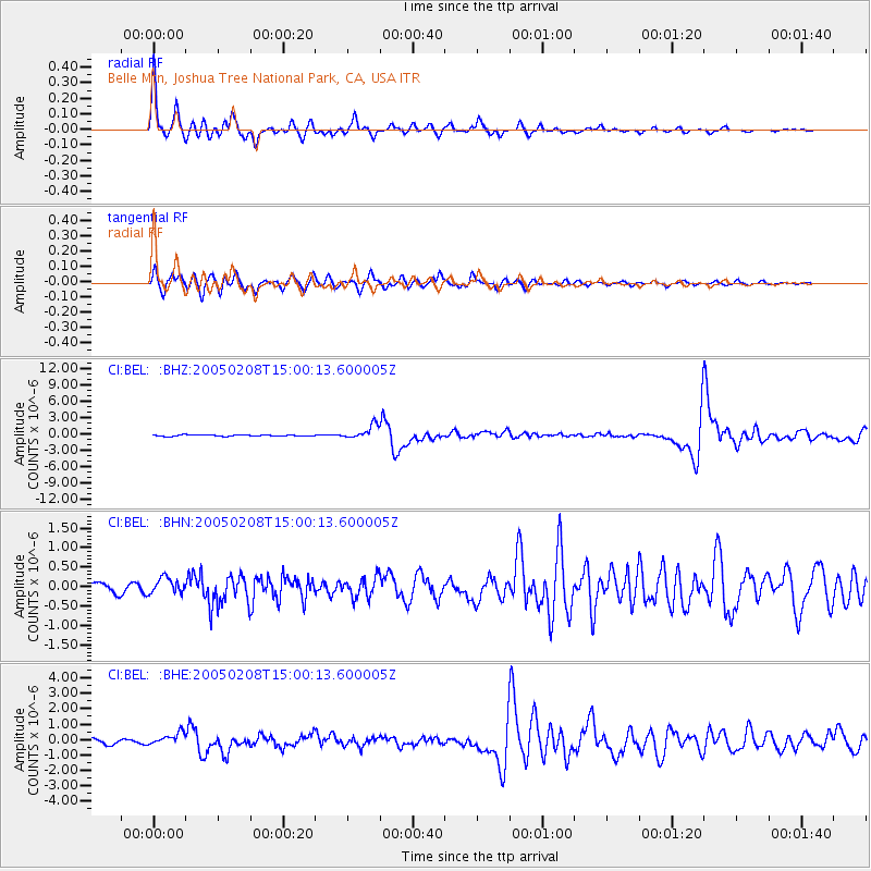
Signal To Noise
| Channel | StoN | STA | LTA |
| CI:BEL: :BHN:20050208T15:00:13.600005Z | 1.4802252 | 2.0296126E-7 | 1.3711512E-7 |
| CI:BEL: :BHE:20050208T15:00:13.600005Z | 1.8786986 | 3.9008046E-7 | 2.0763335E-7 |
| CI:BEL: :BHZ:20050208T15:00:13.600005Z | 10.4214 | 1.2431103E-6 | 1.1928438E-7 |
| Arrivals |
| Ps | 3.6 SECOND |
| PpPs | 12 SECOND |
| PsPs/PpSs | 16 SECOND |


