You are here: Home > Network List > AV - Alaska Volcano Observatory Stations List
> Station SPCR Ckakachatna River, Mount Spurr, Alaska > Earthquake Result Viewer
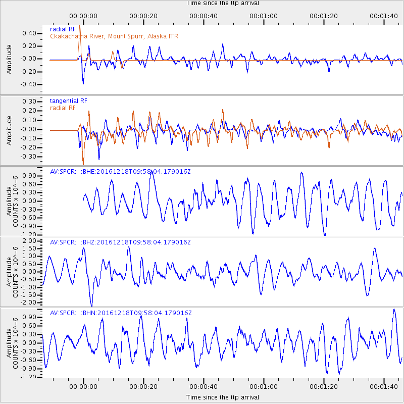
SPCR Ckakachatna River, Mount Spurr, Alaska - Earthquake Result Viewer
*The percent match for this event was below the threshold and hence no stack was calculated.
| Earthquake location: |
W. Caroline Islands, Micronesia |
| Earthquake latitude/longitude: |
8.3/137.7 |
| Earthquake time(UTC): |
2016/12/18 (353) 09:47:08 GMT |
| Earthquake Depth: |
29 km |
| Earthquake Magnitude: |
6.5 Mi |
| Earthquake Catalog/Contributor: |
NEIC PDE/at |
|
| Network: |
AV Alaska Volcano Observatory |
| Station: |
SPCR Ckakachatna River, Mount Spurr, Alaska |
| Lat/Lon: |
61.20 N/152.21 W |
| Elevation: |
984 m |
|
| Distance: |
73.2 deg |
| Az: |
28.394 deg |
| Baz: |
256.382 deg |
| Ray Param: |
$rayparam |
*The percent match for this event was below the threshold and hence was not used in the summary stack. |
|
| Radial Match: |
69.60862 % |
| Radial Bump: |
400 |
| Transverse Match: |
56.4643 % |
| Transverse Bump: |
400 |
| SOD ConfigId: |
11737051 |
| Insert Time: |
2019-04-26 08:49:59.136 +0000 |
| GWidth: |
2.5 |
| Max Bumps: |
400 |
| Tol: |
0.001 |
|
Signal To Noise
| Channel | StoN | STA | LTA |
| AV:SPCR: :BHZ:20161218T09:58:04.179016Z | 2.476054 | 1.1666588E-6 | 4.7117663E-7 |
| AV:SPCR: :BHN:20161218T09:58:04.179016Z | 0.94149196 | 3.3851236E-7 | 3.5954884E-7 |
| AV:SPCR: :BHE:20161218T09:58:04.179016Z | 1.1921585 | 4.9490274E-7 | 4.1513164E-7 |
| Arrivals |
| Ps | |
| PpPs | |
| PsPs/PpSs | |


