You are here: Home > Network List > TA - USArray Transportable Network (new EarthScope stations) Stations List
> Station F26K Sheenjek River, AK, USA > Earthquake Result Viewer
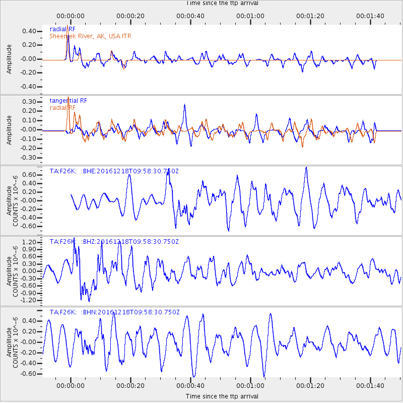
F26K Sheenjek River, AK, USA - Earthquake Result Viewer
*The percent match for this event was below the threshold and hence no stack was calculated.
| Earthquake location: |
W. Caroline Islands, Micronesia |
| Earthquake latitude/longitude: |
8.3/137.7 |
| Earthquake time(UTC): |
2016/12/18 (353) 09:47:08 GMT |
| Earthquake Depth: |
29 km |
| Earthquake Magnitude: |
6.5 Mi |
| Earthquake Catalog/Contributor: |
NEIC PDE/at |
|
| Network: |
TA USArray Transportable Network (new EarthScope stations) |
| Station: |
F26K Sheenjek River, AK, USA |
| Lat/Lon: |
67.69 N/144.15 W |
| Elevation: |
683 m |
|
| Distance: |
77.9 deg |
| Az: |
22.466 deg |
| Baz: |
262.18 deg |
| Ray Param: |
$rayparam |
*The percent match for this event was below the threshold and hence was not used in the summary stack. |
|
| Radial Match: |
70.398636 % |
| Radial Bump: |
400 |
| Transverse Match: |
48.484966 % |
| Transverse Bump: |
335 |
| SOD ConfigId: |
11737051 |
| Insert Time: |
2019-04-26 08:52:50.881 +0000 |
| GWidth: |
2.5 |
| Max Bumps: |
400 |
| Tol: |
0.001 |
|
Signal To Noise
| Channel | StoN | STA | LTA |
| TA:F26K: :BHZ:20161218T09:58:30.750Z | 2.5408385 | 6.810244E-7 | 2.6803136E-7 |
| TA:F26K: :BHN:20161218T09:58:30.750Z | 1.1028981 | 2.4228672E-7 | 2.1968187E-7 |
| TA:F26K: :BHE:20161218T09:58:30.750Z | 1.9355017 | 3.877288E-7 | 2.003247E-7 |
| Arrivals |
| Ps | |
| PpPs | |
| PsPs/PpSs | |


