You are here: Home > Network List > TA - USArray Transportable Network (new EarthScope stations) Stations List
> Station J25K Salcha River, AK, USA > Earthquake Result Viewer
J25K Salcha River, AK, USA - Earthquake Result Viewer
*The percent match for this event was below the threshold and hence no stack was calculated.
| Earthquake location: |
W. Caroline Islands, Micronesia |
| Earthquake latitude/longitude: |
8.3/137.7 |
| Earthquake time(UTC): |
2016/12/18 (353) 09:47:08 GMT |
| Earthquake Depth: |
29 km |
| Earthquake Magnitude: |
6.5 Mi |
| Earthquake Catalog/Contributor: |
NEIC PDE/at |
|
| Network: |
TA USArray Transportable Network (new EarthScope stations) |
| Station: |
J25K Salcha River, AK, USA |
| Lat/Lon: |
64.61 N/145.37 W |
| Elevation: |
949 m |
|
| Distance: |
76.9 deg |
| Az: |
25.535 deg |
| Baz: |
261.73 deg |
| Ray Param: |
$rayparam |
*The percent match for this event was below the threshold and hence was not used in the summary stack. |
|
| Radial Match: |
63.949596 % |
| Radial Bump: |
400 |
| Transverse Match: |
47.699432 % |
| Transverse Bump: |
400 |
| SOD ConfigId: |
11737051 |
| Insert Time: |
2019-04-26 08:53:06.035 +0000 |
| GWidth: |
2.5 |
| Max Bumps: |
400 |
| Tol: |
0.001 |
|
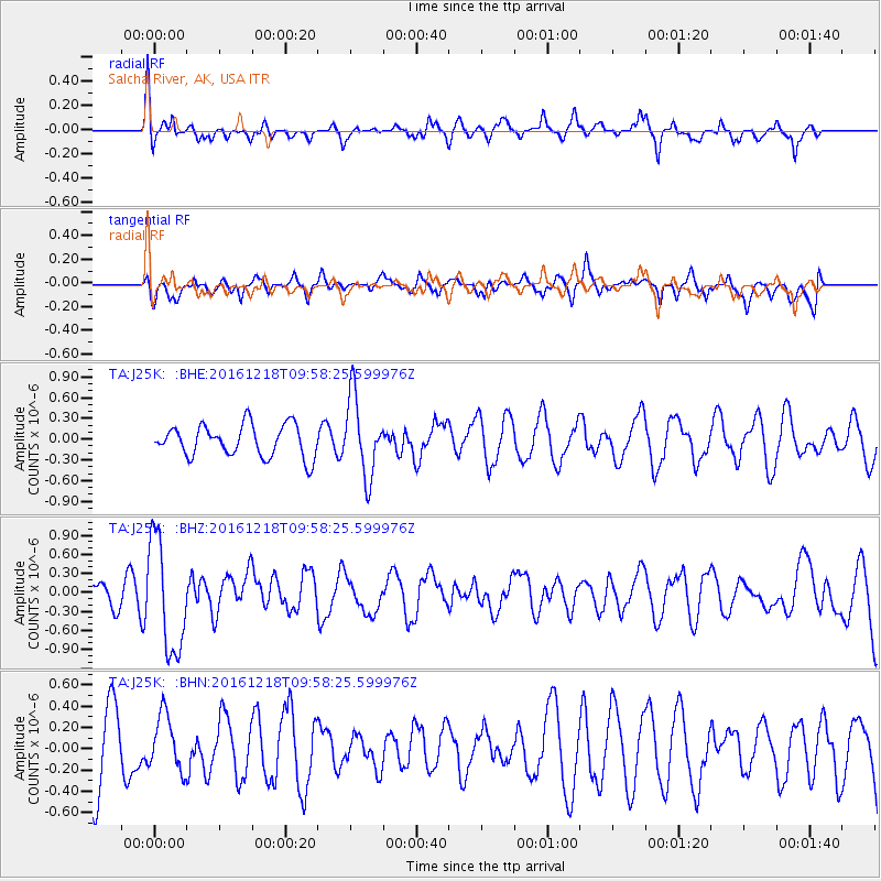
Signal To Noise
| Channel | StoN | STA | LTA |
| TA:J25K: :BHZ:20161218T09:58:25.599976Z | 4.9319267 | 8.8262516E-7 | 1.7896153E-7 |
| TA:J25K: :BHN:20161218T09:58:25.599976Z | 0.83924264 | 2.5989405E-7 | 3.096769E-7 |
| TA:J25K: :BHE:20161218T09:58:25.599976Z | 2.3058379 | 5.3717395E-7 | 2.3296256E-7 |
| Arrivals |
| Ps | |
| PpPs | |
| PsPs/PpSs | |


