You are here: Home > Network List > CI - Caltech Regional Seismic Network Stations List
> Station BEL Belle Mtn, Joshua Tree National Park, CA, USA > Earthquake Result Viewer
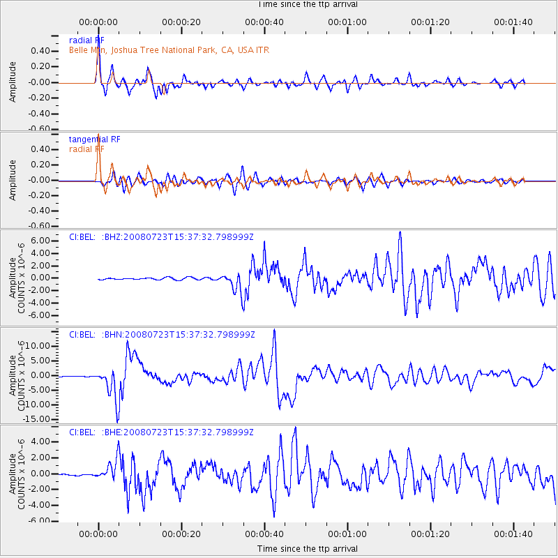
BEL Belle Mtn, Joshua Tree National Park, CA, USA - Earthquake Result Viewer
| Earthquake location: |
Eastern Honshu, Japan |
| Earthquake latitude/longitude: |
39.8/141.5 |
| Earthquake time(UTC): |
2008/07/23 (205) 15:26:19 GMT |
| Earthquake Depth: |
108 km |
| Earthquake Magnitude: |
6.6 MB, 6.8 MW, 6.8 MW |
| Earthquake Catalog/Contributor: |
WHDF/NEIC |
|
| Network: |
CI Caltech Regional Seismic Network |
| Station: |
BEL Belle Mtn, Joshua Tree National Park, CA, USA |
| Lat/Lon: |
34.00 N/116.00 W |
| Elevation: |
1388 m |
|
| Distance: |
77.5 deg |
| Az: |
56.156 deg |
| Baz: |
309.63 deg |
| Ray Param: |
0.050009545 |
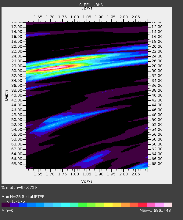
| Estimated Moho Depth: |
28.5 km |
| Estimated Crust Vp/Vs: |
1.72 |
| Assumed Crust Vp: |
6.276 km/s |
| Estimated Crust Vs: |
3.654 km/s |
| Estimated Crust Poisson's Ratio: |
0.24 |
|
| Radial Match: |
94.6729 % |
| Radial Bump: |
332 |
| Transverse Match: |
75.42074 % |
| Transverse Bump: |
400 |
| SOD ConfigId: |
2504 |
| Insert Time: |
2010-03-05 20:40:46.426 +0000 |
| GWidth: |
2.5 |
| Max Bumps: |
400 |
| Tol: |
0.001 |
|
Signal To Noise
| Channel | StoN | STA | LTA |
| CI:BEL: :BHN:20080723T15:37:32.798999Z | 37.70333 | 5.664873E-6 | 1.5024861E-7 |
| CI:BEL: :BHE:20080723T15:37:32.798999Z | 22.685371 | 1.2973626E-6 | 5.7189393E-8 |
| CI:BEL: :BHZ:20080723T15:37:32.798999Z | 9.777081 | 1.6706081E-6 | 1.7086984E-7 |
| Arrivals |
| Ps | 3.4 SECOND |
| PpPs | 12 SECOND |
| PsPs/PpSs | 15 SECOND |


