You are here: Home > Network List > TA - USArray Transportable Network (new EarthScope stations) Stations List
> Station L20K Farewell, AK, USA > Earthquake Result Viewer
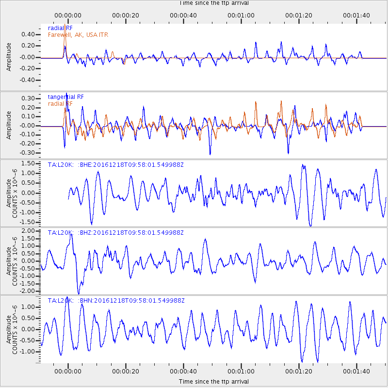
L20K Farewell, AK, USA - Earthquake Result Viewer
*The percent match for this event was below the threshold and hence no stack was calculated.
| Earthquake location: |
W. Caroline Islands, Micronesia |
| Earthquake latitude/longitude: |
8.3/137.7 |
| Earthquake time(UTC): |
2016/12/18 (353) 09:47:08 GMT |
| Earthquake Depth: |
29 km |
| Earthquake Magnitude: |
6.5 Mi |
| Earthquake Catalog/Contributor: |
NEIC PDE/at |
|
| Network: |
TA USArray Transportable Network (new EarthScope stations) |
| Station: |
L20K Farewell, AK, USA |
| Lat/Lon: |
62.48 N/153.88 W |
| Elevation: |
673 m |
|
| Distance: |
72.8 deg |
| Az: |
26.887 deg |
| Baz: |
254.471 deg |
| Ray Param: |
$rayparam |
*The percent match for this event was below the threshold and hence was not used in the summary stack. |
|
| Radial Match: |
57.106487 % |
| Radial Bump: |
400 |
| Transverse Match: |
55.617645 % |
| Transverse Bump: |
400 |
| SOD ConfigId: |
11737051 |
| Insert Time: |
2019-04-26 08:53:13.651 +0000 |
| GWidth: |
2.5 |
| Max Bumps: |
400 |
| Tol: |
0.001 |
|
Signal To Noise
| Channel | StoN | STA | LTA |
| TA:L20K: :BHZ:20161218T09:58:01.549988Z | 2.0629537 | 1.31995E-6 | 6.3983504E-7 |
| TA:L20K: :BHN:20161218T09:58:01.549988Z | 1.5065094 | 8.681091E-7 | 5.7623873E-7 |
| TA:L20K: :BHE:20161218T09:58:01.549988Z | 0.7015314 | 3.9914823E-7 | 5.6896704E-7 |
| Arrivals |
| Ps | |
| PpPs | |
| PsPs/PpSs | |


