You are here: Home > Network List > TA - USArray Transportable Network (new EarthScope stations) Stations List
> Station R33M Jennings River, BC, CAN > Earthquake Result Viewer
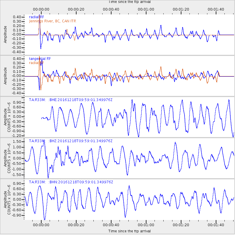
R33M Jennings River, BC, CAN - Earthquake Result Viewer
*The percent match for this event was below the threshold and hence no stack was calculated.
| Earthquake location: |
W. Caroline Islands, Micronesia |
| Earthquake latitude/longitude: |
8.3/137.7 |
| Earthquake time(UTC): |
2016/12/18 (353) 09:47:08 GMT |
| Earthquake Depth: |
29 km |
| Earthquake Magnitude: |
6.5 Mi |
| Earthquake Catalog/Contributor: |
NEIC PDE/at |
|
| Network: |
TA USArray Transportable Network (new EarthScope stations) |
| Station: |
R33M Jennings River, BC, CAN |
| Lat/Lon: |
59.39 N/130.97 W |
| Elevation: |
1437 m |
|
| Distance: |
83.6 deg |
| Az: |
30.979 deg |
| Baz: |
275.379 deg |
| Ray Param: |
$rayparam |
*The percent match for this event was below the threshold and hence was not used in the summary stack. |
|
| Radial Match: |
47.17274 % |
| Radial Bump: |
400 |
| Transverse Match: |
58.146675 % |
| Transverse Bump: |
400 |
| SOD ConfigId: |
11737051 |
| Insert Time: |
2019-04-26 08:53:36.304 +0000 |
| GWidth: |
2.5 |
| Max Bumps: |
400 |
| Tol: |
0.001 |
|
Signal To Noise
| Channel | StoN | STA | LTA |
| TA:R33M: :BHZ:20161218T09:59:01.349976Z | 3.2401235 | 1.0545917E-6 | 3.2547885E-7 |
| TA:R33M: :BHN:20161218T09:59:01.349976Z | 1.8833776 | 6.343485E-7 | 3.3681428E-7 |
| TA:R33M: :BHE:20161218T09:59:01.349976Z | 1.0109099 | 4.5100586E-7 | 4.4613853E-7 |
| Arrivals |
| Ps | |
| PpPs | |
| PsPs/PpSs | |


