You are here: Home > Network List > CI - Caltech Regional Seismic Network Stations List
> Station BEL Belle Mtn, Joshua Tree National Park, CA, USA > Earthquake Result Viewer
BEL Belle Mtn, Joshua Tree National Park, CA, USA - Earthquake Result Viewer
| Earthquake location: |
Volcano Islands, Japan Region |
| Earthquake latitude/longitude: |
22.0/142.7 |
| Earthquake time(UTC): |
2007/09/28 (271) 13:38:59 GMT |
| Earthquake Depth: |
276 km |
| Earthquake Magnitude: |
6.7 MB, 7.4 MW, 7.4 MW |
| Earthquake Catalog/Contributor: |
WHDF/NEIC |
|
| Network: |
CI Caltech Regional Seismic Network |
| Station: |
BEL Belle Mtn, Joshua Tree National Park, CA, USA |
| Lat/Lon: |
34.00 N/116.00 W |
| Elevation: |
1388 m |
|
| Distance: |
86.8 deg |
| Az: |
54.665 deg |
| Baz: |
294.316 deg |
| Ray Param: |
0.043105602 |
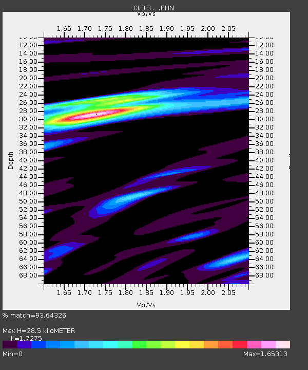
| Estimated Moho Depth: |
28.5 km |
| Estimated Crust Vp/Vs: |
1.73 |
| Assumed Crust Vp: |
6.276 km/s |
| Estimated Crust Vs: |
3.633 km/s |
| Estimated Crust Poisson's Ratio: |
0.25 |
|
| Radial Match: |
93.64326 % |
| Radial Bump: |
400 |
| Transverse Match: |
84.71064 % |
| Transverse Bump: |
400 |
| SOD ConfigId: |
2564 |
| Insert Time: |
2010-03-05 20:41:23.471 +0000 |
| GWidth: |
2.5 |
| Max Bumps: |
400 |
| Tol: |
0.001 |
|
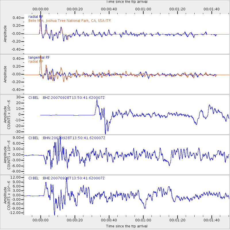
Signal To Noise
| Channel | StoN | STA | LTA |
| CI:BEL: :BHN:20070928T13:50:41.620007Z | 19.667234 | 1.7543811E-6 | 8.920324E-8 |
| CI:BEL: :BHE:20070928T13:50:41.620007Z | 35.64224 | 3.6499516E-6 | 1.0240523E-7 |
| CI:BEL: :BHZ:20070928T13:50:41.620007Z | 70.15075 | 1.0756262E-5 | 1.5333069E-7 |
| Arrivals |
| Ps | 3.4 SECOND |
| PpPs | 12 SECOND |
| PsPs/PpSs | 15 SECOND |


