You are here: Home > Network List > AK - Alaska Regional Network Stations List
> Station MDM Murphy Dome > Earthquake Result Viewer
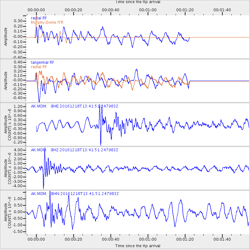
MDM Murphy Dome - Earthquake Result Viewer
*The percent match for this event was below the threshold and hence no stack was calculated.
| Earthquake location: |
Peru-Brazil Border Region |
| Earthquake latitude/longitude: |
-10.0/-71.0 |
| Earthquake time(UTC): |
2016/12/18 (353) 13:30:11 GMT |
| Earthquake Depth: |
619 km |
| Earthquake Magnitude: |
6.4 Mww |
| Earthquake Catalog/Contributor: |
NEIC PDE/us |
|
| Network: |
AK Alaska Regional Network |
| Station: |
MDM Murphy Dome |
| Lat/Lon: |
64.96 N/148.23 W |
| Elevation: |
634 m |
|
| Distance: |
93.6 deg |
| Az: |
335.42 deg |
| Baz: |
105.681 deg |
| Ray Param: |
$rayparam |
*The percent match for this event was below the threshold and hence was not used in the summary stack. |
|
| Radial Match: |
67.87104 % |
| Radial Bump: |
400 |
| Transverse Match: |
41.55306 % |
| Transverse Bump: |
400 |
| SOD ConfigId: |
11737051 |
| Insert Time: |
2019-04-26 09:02:52.842 +0000 |
| GWidth: |
2.5 |
| Max Bumps: |
400 |
| Tol: |
0.001 |
|
Signal To Noise
| Channel | StoN | STA | LTA |
| AK:MDM: :BHZ:20161218T13:41:51.247983Z | 7.3300867 | 1.4599943E-6 | 1.9917833E-7 |
| AK:MDM: :BHN:20161218T13:41:51.247983Z | 1.9938592 | 4.6197397E-7 | 2.316984E-7 |
| AK:MDM: :BHE:20161218T13:41:51.247983Z | 2.1796083 | 4.623707E-7 | 2.1213476E-7 |
| Arrivals |
| Ps | |
| PpPs | |
| PsPs/PpSs | |


