You are here: Home > Network List > AZ - ANZA Regional Network Stations List
> Station SMER AZ.SMER > Earthquake Result Viewer
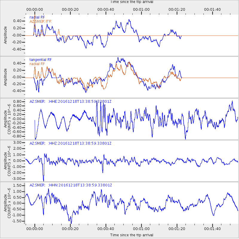
SMER AZ.SMER - Earthquake Result Viewer
*The percent match for this event was below the threshold and hence no stack was calculated.
| Earthquake location: |
Peru-Brazil Border Region |
| Earthquake latitude/longitude: |
-10.0/-71.0 |
| Earthquake time(UTC): |
2016/12/18 (353) 13:30:11 GMT |
| Earthquake Depth: |
619 km |
| Earthquake Magnitude: |
6.4 Mww |
| Earthquake Catalog/Contributor: |
NEIC PDE/us |
|
| Network: |
AZ ANZA Regional Network |
| Station: |
SMER AZ.SMER |
| Lat/Lon: |
33.46 N/117.17 W |
| Elevation: |
355 m |
|
| Distance: |
61.6 deg |
| Az: |
316.688 deg |
| Baz: |
126.068 deg |
| Ray Param: |
$rayparam |
*The percent match for this event was below the threshold and hence was not used in the summary stack. |
|
| Radial Match: |
65.47907 % |
| Radial Bump: |
400 |
| Transverse Match: |
73.763214 % |
| Transverse Bump: |
400 |
| SOD ConfigId: |
11737051 |
| Insert Time: |
2019-04-26 09:03:33.097 +0000 |
| GWidth: |
2.5 |
| Max Bumps: |
400 |
| Tol: |
0.001 |
|
Signal To Noise
| Channel | StoN | STA | LTA |
| AZ:SMER: :HHZ:20161218T13:38:59.33801Z | 4.3603115 | 8.6642524E-7 | 1.9870718E-7 |
| AZ:SMER: :HHN:20161218T13:38:59.33801Z | 2.631842 | 7.302341E-7 | 2.7746123E-7 |
| AZ:SMER: :HHE:20161218T13:38:59.33801Z | 0.82704246 | 2.483753E-7 | 3.0031748E-7 |
| Arrivals |
| Ps | |
| PpPs | |
| PsPs/PpSs | |


