You are here: Home > Network List > CI - Caltech Regional Seismic Network Stations List
> Station BEL Belle Mtn, Joshua Tree National Park, CA, USA > Earthquake Result Viewer
BEL Belle Mtn, Joshua Tree National Park, CA, USA - Earthquake Result Viewer
| Earthquake location: |
Panama-Costa Rica Border Region |
| Earthquake latitude/longitude: |
8.3/-83.0 |
| Earthquake time(UTC): |
2008/11/19 (324) 06:11:20 GMT |
| Earthquake Depth: |
32 km |
| Earthquake Magnitude: |
5.9 MB, 5.9 MS, 6.2 MW, 6.1 MW |
| Earthquake Catalog/Contributor: |
WHDF/NEIC |
|
| Network: |
CI Caltech Regional Seismic Network |
| Station: |
BEL Belle Mtn, Joshua Tree National Park, CA, USA |
| Lat/Lon: |
34.00 N/116.00 W |
| Elevation: |
1388 m |
|
| Distance: |
39.7 deg |
| Az: |
314.91 deg |
| Baz: |
122.462 deg |
| Ray Param: |
0.07474125 |
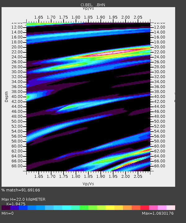
| Estimated Moho Depth: |
22.0 km |
| Estimated Crust Vp/Vs: |
1.95 |
| Assumed Crust Vp: |
6.276 km/s |
| Estimated Crust Vs: |
3.222 km/s |
| Estimated Crust Poisson's Ratio: |
0.32 |
|
| Radial Match: |
91.69166 % |
| Radial Bump: |
400 |
| Transverse Match: |
88.65857 % |
| Transverse Bump: |
400 |
| SOD ConfigId: |
2658 |
| Insert Time: |
2010-03-05 20:42:12.860 +0000 |
| GWidth: |
2.5 |
| Max Bumps: |
400 |
| Tol: |
0.001 |
|

Signal To Noise
| Channel | StoN | STA | LTA |
| CI:BEL: :BHN:20081119T06:18:19.950004Z | 5.467974 | 5.930621E-7 | 1.0846103E-7 |
| CI:BEL: :BHE:20081119T06:18:19.950004Z | 1.1842831 | 1.5727133E-7 | 1.3279875E-7 |
| CI:BEL: :BHZ:20081119T06:18:19.950004Z | 2.4780443 | 2.8823672E-7 | 1.16316215E-7 |
| Arrivals |
| Ps | 3.5 SECOND |
| PpPs | 9.7 SECOND |
| PsPs/PpSs | 13 SECOND |


