You are here: Home > Network List > GS - US Geological Survey Networks Stations List
> Station KAN13 Rinehart Farm, , CA, USA > Earthquake Result Viewer
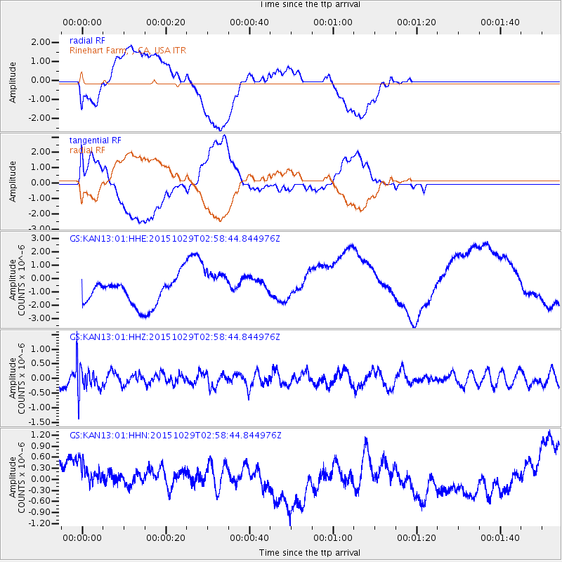
KAN13 Rinehart Farm, , CA, USA - Earthquake Result Viewer
*The percent match for this event was below the threshold and hence no stack was calculated.
| Earthquake location: |
Rat Islands, Aleutian Islands |
| Earthquake latitude/longitude: |
51.8/178.5 |
| Earthquake time(UTC): |
2015/10/29 (302) 02:49:28 GMT |
| Earthquake Depth: |
88 km |
| Earthquake Magnitude: |
5.6 MB |
| Earthquake Catalog/Contributor: |
NEIC PDE/NEIC COMCAT |
|
| Network: |
GS US Geological Survey Networks |
| Station: |
KAN13 Rinehart Farm, , CA, USA |
| Lat/Lon: |
37.01 N/97.48 W |
| Elevation: |
340 m |
|
| Distance: |
58.5 deg |
| Az: |
68.938 deg |
| Baz: |
313.64 deg |
| Ray Param: |
$rayparam |
*The percent match for this event was below the threshold and hence was not used in the summary stack. |
|
| Radial Match: |
55.24505 % |
| Radial Bump: |
400 |
| Transverse Match: |
40.464214 % |
| Transverse Bump: |
400 |
| SOD ConfigId: |
1259291 |
| Insert Time: |
2015-11-12 03:00:22.962 +0000 |
| GWidth: |
2.5 |
| Max Bumps: |
400 |
| Tol: |
0.001 |
|
Signal To Noise
| Channel | StoN | STA | LTA |
| GS:KAN13:01:HHZ:20151029T02:58:44.844976Z | 1.632699 | 3.7929522E-7 | 2.3231179E-7 |
| GS:KAN13:01:HHN:20151029T02:58:44.844976Z | 1.1379225 | 6.4000255E-7 | 5.6243067E-7 |
| GS:KAN13:01:HHE:20151029T02:58:44.844976Z | 1.3918414 | 1.3997192E-6 | 1.0056599E-6 |
| Arrivals |
| Ps | |
| PpPs | |
| PsPs/PpSs | |


