You are here: Home > Network List > CI - Caltech Regional Seismic Network Stations List
> Station DGR Domenigoni Reservoir, California, USA > Earthquake Result Viewer
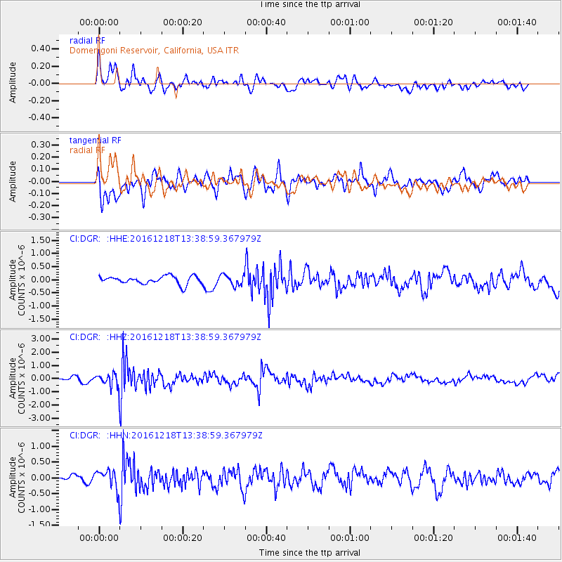
DGR Domenigoni Reservoir, California, USA - Earthquake Result Viewer
*The percent match for this event was below the threshold and hence no stack was calculated.
| Earthquake location: |
Peru-Brazil Border Region |
| Earthquake latitude/longitude: |
-10.0/-71.0 |
| Earthquake time(UTC): |
2016/12/18 (353) 13:30:11 GMT |
| Earthquake Depth: |
619 km |
| Earthquake Magnitude: |
6.4 Mww |
| Earthquake Catalog/Contributor: |
NEIC PDE/us |
|
| Network: |
CI Caltech Regional Seismic Network |
| Station: |
DGR Domenigoni Reservoir, California, USA |
| Lat/Lon: |
33.65 N/117.01 W |
| Elevation: |
609 m |
|
| Distance: |
61.6 deg |
| Az: |
316.955 deg |
| Baz: |
126.284 deg |
| Ray Param: |
$rayparam |
*The percent match for this event was below the threshold and hence was not used in the summary stack. |
|
| Radial Match: |
61.53505 % |
| Radial Bump: |
400 |
| Transverse Match: |
75.05961 % |
| Transverse Bump: |
400 |
| SOD ConfigId: |
11737051 |
| Insert Time: |
2019-04-26 09:04:23.425 +0000 |
| GWidth: |
2.5 |
| Max Bumps: |
400 |
| Tol: |
0.001 |
|
Signal To Noise
| Channel | StoN | STA | LTA |
| CI:DGR: :HHZ:20161218T13:38:59.367979Z | 2.3744078 | 5.294064E-7 | 2.2296355E-7 |
| CI:DGR: :HHN:20161218T13:38:59.367979Z | 2.3186343 | 3.1863502E-7 | 1.3742358E-7 |
| CI:DGR: :HHE:20161218T13:38:59.367979Z | 1.37672 | 2.0906994E-7 | 1.5186092E-7 |
| Arrivals |
| Ps | |
| PpPs | |
| PsPs/PpSs | |


