You are here: Home > Network List > CI - Caltech Regional Seismic Network Stations List
> Station BEL Belle Mtn, Joshua Tree National Park, CA, USA > Earthquake Result Viewer
BEL Belle Mtn, Joshua Tree National Park, CA, USA - Earthquake Result Viewer
| Earthquake location: |
Samoa Islands Region |
| Earthquake latitude/longitude: |
-15.6/-172.0 |
| Earthquake time(UTC): |
2009/09/29 (272) 18:08:21 GMT |
| Earthquake Depth: |
10 km |
| Earthquake Magnitude: |
5.6 MB |
| Earthquake Catalog/Contributor: |
WHDF/NEIC |
|
| Network: |
CI Caltech Regional Seismic Network |
| Station: |
BEL Belle Mtn, Joshua Tree National Park, CA, USA |
| Lat/Lon: |
34.00 N/116.00 W |
| Elevation: |
1388 m |
|
| Distance: |
72.6 deg |
| Az: |
46.215 deg |
| Baz: |
236.885 deg |
| Ray Param: |
0.053560246 |
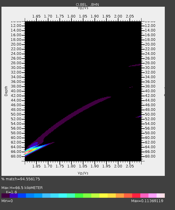
| Estimated Moho Depth: |
66.5 km |
| Estimated Crust Vp/Vs: |
1.60 |
| Assumed Crust Vp: |
6.276 km/s |
| Estimated Crust Vs: |
3.922 km/s |
| Estimated Crust Poisson's Ratio: |
0.18 |
|
| Radial Match: |
94.556175 % |
| Radial Bump: |
223 |
| Transverse Match: |
42.090588 % |
| Transverse Bump: |
289 |
| SOD ConfigId: |
2622 |
| Insert Time: |
2010-03-05 20:42:38.611 +0000 |
| GWidth: |
2.5 |
| Max Bumps: |
400 |
| Tol: |
0.001 |
|
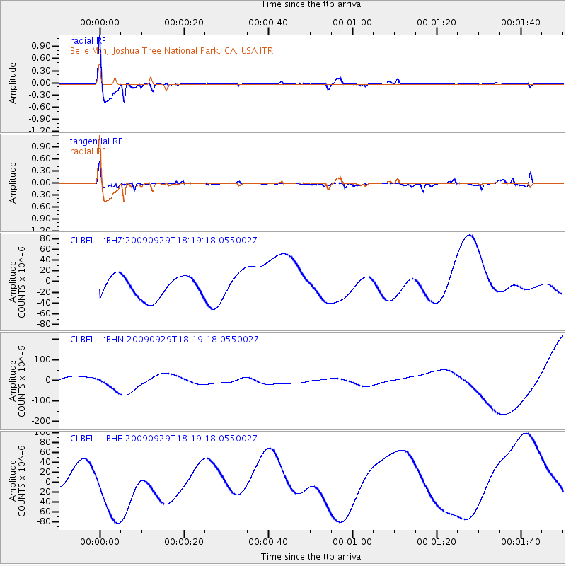
Signal To Noise
| Channel | StoN | STA | LTA |
| CI:BEL: :BHN:20090929T18:19:18.055002Z | 2.0624044 | 3.7389393E-5 | 1.8129032E-5 |
| CI:BEL: :BHE:20090929T18:19:18.055002Z | 2.6083045 | 6.774689E-5 | 2.5973537E-5 |
| CI:BEL: :BHZ:20090929T18:19:18.055002Z | 1.1602085 | 2.2654756E-5 | 1.9526453E-5 |
| Arrivals |
| Ps | 6.6 SECOND |
| PpPs | 27 SECOND |
| PsPs/PpSs | 33 SECOND |


