You are here: Home > Network List > CI - Caltech Regional Seismic Network Stations List
> Station VCS Vincent Substation, Palmdale, CA, USA > Earthquake Result Viewer
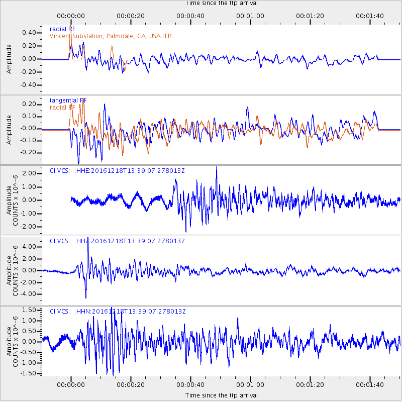
VCS Vincent Substation, Palmdale, CA, USA - Earthquake Result Viewer
*The percent match for this event was below the threshold and hence no stack was calculated.
| Earthquake location: |
Peru-Brazil Border Region |
| Earthquake latitude/longitude: |
-10.0/-71.0 |
| Earthquake time(UTC): |
2016/12/18 (353) 13:30:11 GMT |
| Earthquake Depth: |
619 km |
| Earthquake Magnitude: |
6.4 Mww |
| Earthquake Catalog/Contributor: |
NEIC PDE/us |
|
| Network: |
CI Caltech Regional Seismic Network |
| Station: |
VCS Vincent Substation, Palmdale, CA, USA |
| Lat/Lon: |
34.48 N/118.12 W |
| Elevation: |
991 m |
|
| Distance: |
62.8 deg |
| Az: |
317.103 deg |
| Baz: |
125.735 deg |
| Ray Param: |
$rayparam |
*The percent match for this event was below the threshold and hence was not used in the summary stack. |
|
| Radial Match: |
55.42188 % |
| Radial Bump: |
400 |
| Transverse Match: |
73.45877 % |
| Transverse Bump: |
400 |
| SOD ConfigId: |
11737051 |
| Insert Time: |
2019-04-26 09:04:59.063 +0000 |
| GWidth: |
2.5 |
| Max Bumps: |
400 |
| Tol: |
0.001 |
|
Signal To Noise
| Channel | StoN | STA | LTA |
| CI:VCS: :HHZ:20161218T13:39:07.278013Z | 3.0181577 | 9.0960015E-7 | 3.0137593E-7 |
| CI:VCS: :HHN:20161218T13:39:07.278013Z | 1.9159155 | 3.2088772E-7 | 1.6748533E-7 |
| CI:VCS: :HHE:20161218T13:39:07.278013Z | 1.695122 | 4.4679447E-7 | 2.635766E-7 |
| Arrivals |
| Ps | |
| PpPs | |
| PsPs/PpSs | |


