You are here: Home > Network List > GT - Global Telemetered Seismograph Network (USAF/USGS) Stations List
> Station PLCA Paso Flores, Argentina > Earthquake Result Viewer
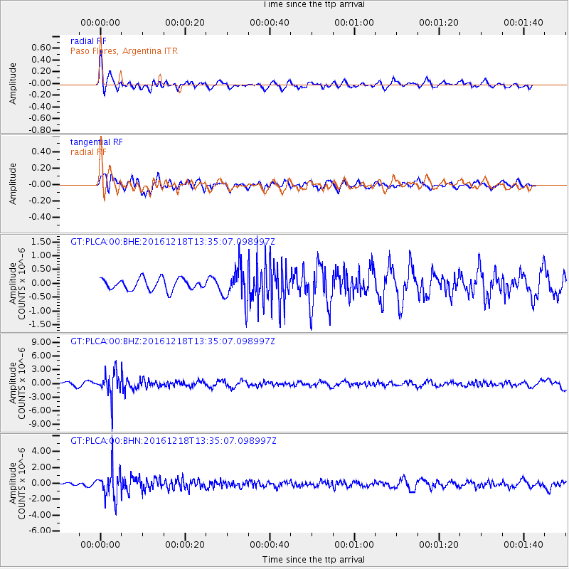
PLCA Paso Flores, Argentina - Earthquake Result Viewer
*The percent match for this event was below the threshold and hence no stack was calculated.
| Earthquake location: |
Peru-Brazil Border Region |
| Earthquake latitude/longitude: |
-10.0/-71.0 |
| Earthquake time(UTC): |
2016/12/18 (353) 13:30:11 GMT |
| Earthquake Depth: |
619 km |
| Earthquake Magnitude: |
6.4 Mww |
| Earthquake Catalog/Contributor: |
NEIC PDE/us |
|
| Network: |
GT Global Telemetered Seismograph Network (USAF/USGS) |
| Station: |
PLCA Paso Flores, Argentina |
| Lat/Lon: |
40.73 S/70.55 W |
| Elevation: |
1050 m |
|
| Distance: |
30.6 deg |
| Az: |
179.382 deg |
| Baz: |
359.198 deg |
| Ray Param: |
$rayparam |
*The percent match for this event was below the threshold and hence was not used in the summary stack. |
|
| Radial Match: |
56.44819 % |
| Radial Bump: |
400 |
| Transverse Match: |
43.615597 % |
| Transverse Bump: |
400 |
| SOD ConfigId: |
11737051 |
| Insert Time: |
2019-04-26 09:06:35.002 +0000 |
| GWidth: |
2.5 |
| Max Bumps: |
400 |
| Tol: |
0.001 |
|
Signal To Noise
| Channel | StoN | STA | LTA |
| GT:PLCA:00:BHZ:20161218T13:35:07.098997Z | 6.8894815 | 2.6699104E-6 | 3.875343E-7 |
| GT:PLCA:00:BHN:20161218T13:35:07.098997Z | 7.5567927 | 1.7971804E-6 | 2.3782317E-7 |
| GT:PLCA:00:BHE:20161218T13:35:07.098997Z | 3.0815806 | 6.289671E-7 | 2.0410535E-7 |
| Arrivals |
| Ps | |
| PpPs | |
| PsPs/PpSs | |


