You are here: Home > Network List > CI - Caltech Regional Seismic Network Stations List
> Station BEL Belle Mtn, Joshua Tree National Park, CA, USA > Earthquake Result Viewer
BEL Belle Mtn, Joshua Tree National Park, CA, USA - Earthquake Result Viewer
| Earthquake location: |
Eastern Siberia, Russia |
| Earthquake latitude/longitude: |
60.9/167.1 |
| Earthquake time(UTC): |
2006/04/20 (110) 23:25:02 GMT |
| Earthquake Depth: |
22 km |
| Earthquake Magnitude: |
6.8 MB, 7.6 MS, 7.6 MW, 7.3 MW |
| Earthquake Catalog/Contributor: |
WHDF/NEIC |
|
| Network: |
CI Caltech Regional Seismic Network |
| Station: |
BEL Belle Mtn, Joshua Tree National Park, CA, USA |
| Lat/Lon: |
34.00 N/116.00 W |
| Elevation: |
1388 m |
|
| Distance: |
54.7 deg |
| Az: |
82.433 deg |
| Baz: |
324.381 deg |
| Ray Param: |
0.065243624 |
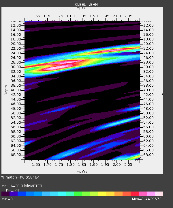
| Estimated Moho Depth: |
30.0 km |
| Estimated Crust Vp/Vs: |
1.74 |
| Assumed Crust Vp: |
6.276 km/s |
| Estimated Crust Vs: |
3.607 km/s |
| Estimated Crust Poisson's Ratio: |
0.25 |
|
| Radial Match: |
96.058464 % |
| Radial Bump: |
400 |
| Transverse Match: |
90.43779 % |
| Transverse Bump: |
400 |
| SOD ConfigId: |
2669 |
| Insert Time: |
2010-03-05 20:44:11.389 +0000 |
| GWidth: |
2.5 |
| Max Bumps: |
400 |
| Tol: |
0.001 |
|
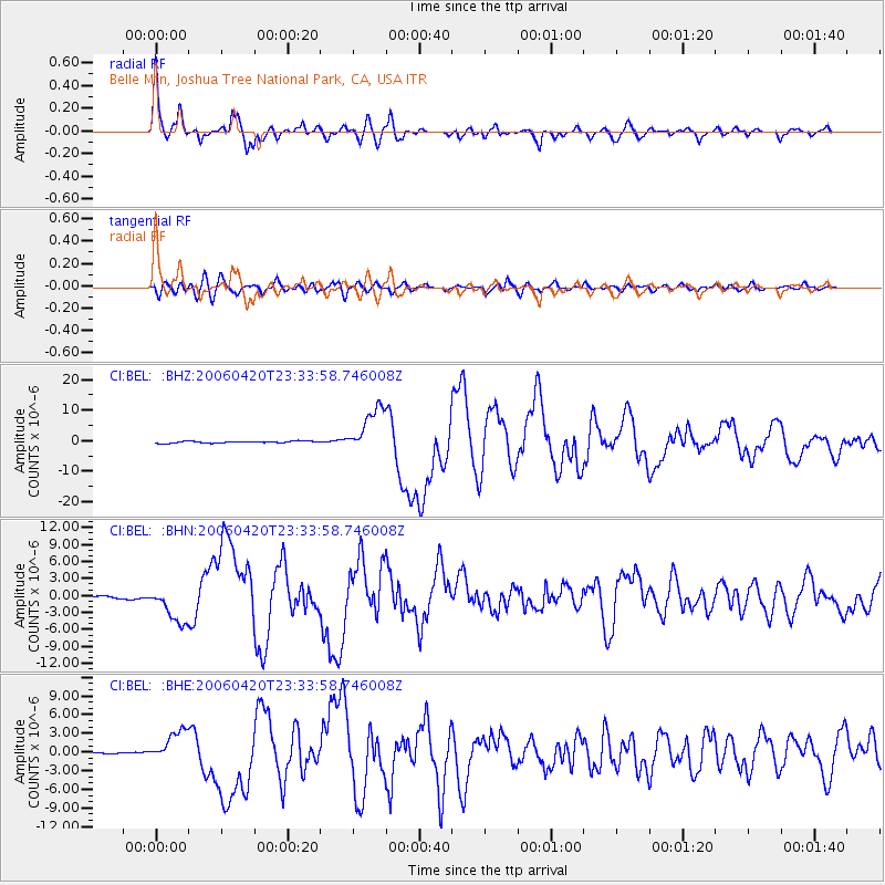
Signal To Noise
| Channel | StoN | STA | LTA |
| CI:BEL: :BHN:20060420T23:33:58.746008Z | 19.262165 | 3.2431067E-6 | 1.6836668E-7 |
| CI:BEL: :BHE:20060420T23:33:58.746008Z | 9.788885 | 2.576908E-6 | 2.6324835E-7 |
| CI:BEL: :BHZ:20060420T23:33:58.746008Z | 24.414434 | 7.670149E-6 | 3.141645E-7 |
| Arrivals |
| Ps | 3.7 SECOND |
| PpPs | 12 SECOND |
| PsPs/PpSs | 16 SECOND |


