You are here: Home > Network List > CI - Caltech Regional Seismic Network Stations List
> Station BEL Belle Mtn, Joshua Tree National Park, CA, USA > Earthquake Result Viewer
BEL Belle Mtn, Joshua Tree National Park, CA, USA - Earthquake Result Viewer
| Earthquake location: |
Fiji Islands Region |
| Earthquake latitude/longitude: |
-19.9/-178.2 |
| Earthquake time(UTC): |
2006/01/02 (002) 22:13:40 GMT |
| Earthquake Depth: |
583 km |
| Earthquake Magnitude: |
6.5 MB, 7.2 MW, 7.1 MW |
| Earthquake Catalog/Contributor: |
WHDF/NEIC |
|
| Network: |
CI Caltech Regional Seismic Network |
| Station: |
BEL Belle Mtn, Joshua Tree National Park, CA, USA |
| Lat/Lon: |
34.00 N/116.00 W |
| Elevation: |
1388 m |
|
| Distance: |
79.9 deg |
| Az: |
48.282 deg |
| Baz: |
237.709 deg |
| Ray Param: |
0.046885822 |
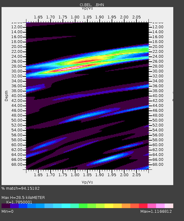
| Estimated Moho Depth: |
28.5 km |
| Estimated Crust Vp/Vs: |
1.79 |
| Assumed Crust Vp: |
6.276 km/s |
| Estimated Crust Vs: |
3.516 km/s |
| Estimated Crust Poisson's Ratio: |
0.27 |
|
| Radial Match: |
94.15182 % |
| Radial Bump: |
400 |
| Transverse Match: |
88.519325 % |
| Transverse Bump: |
400 |
| SOD ConfigId: |
2422 |
| Insert Time: |
2010-03-05 20:44:22.449 +0000 |
| GWidth: |
2.5 |
| Max Bumps: |
400 |
| Tol: |
0.001 |
|
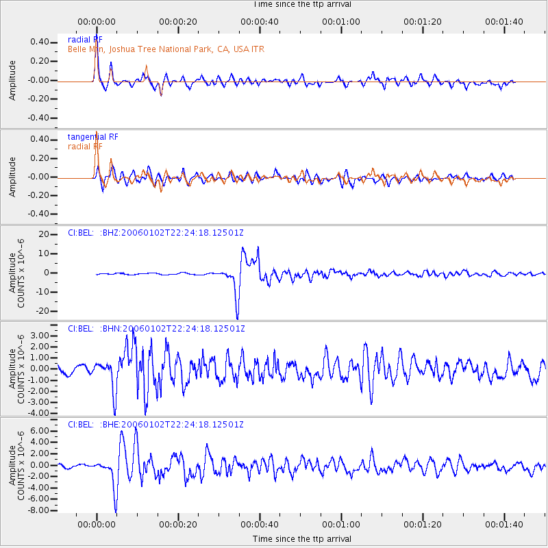
Signal To Noise
| Channel | StoN | STA | LTA |
| CI:BEL: :BHN:20060102T22:24:18.12501Z | 3.9470413 | 1.3886948E-6 | 3.5183183E-7 |
| CI:BEL: :BHE:20060102T22:24:18.12501Z | 9.454994 | 2.5603704E-6 | 2.7079554E-7 |
| CI:BEL: :BHZ:20060102T22:24:18.12501Z | 20.716082 | 8.001921E-6 | 3.8626615E-7 |
| Arrivals |
| Ps | 3.7 SECOND |
| PpPs | 12 SECOND |
| PsPs/PpSs | 16 SECOND |


