You are here: Home > Network List > CI - Caltech Regional Seismic Network Stations List
> Station SDD Saddleback, Mission Viejo, CA, USA > Earthquake Result Viewer
SDD Saddleback, Mission Viejo, CA, USA - Earthquake Result Viewer

| Earthquake location: |
Near West Coast Of Colombia |
| Earthquake latitude/longitude: |
3.0/-78.0 |
| Earthquake time(UTC): |
2007/09/10 (253) 01:49:14 GMT |
| Earthquake Depth: |
31 km |
| Earthquake Magnitude: |
6.1 MB, 6.7 MS, 6.8 MW |
| Earthquake Catalog/Contributor: |
WHDF/NEIC |
|
| Network: |
CI Caltech Regional Seismic Network |
| Station: |
SDD Saddleback, Mission Viejo, CA, USA |
| Lat/Lon: |
33.55 N/117.66 W |
| Elevation: |
120 m |
|
| Distance: |
47.9 deg |
| Az: |
314.062 deg |
| Baz: |
120.757 deg |
| Ray Param: |
0.06962777 |
| Estimated Moho Depth: |
11.0 km |
| Estimated Crust Vp/Vs: |
1.60 |
| Assumed Crust Vp: |
6.264 km/s |
| Estimated Crust Vs: |
3.915 km/s |
| Estimated Crust Poisson's Ratio: |
0.18 |
|
| Radial Match: |
87.482605 % |
| Radial Bump: |
400 |
| Transverse Match: |
82.46048 % |
| Transverse Bump: |
400 |
| SOD ConfigId: |
2564 |
| Insert Time: |
2010-02-26 00:57:31.875 +0000 |
| GWidth: |
2.5 |
| Max Bumps: |
400 |
| Tol: |
0.001 |
|
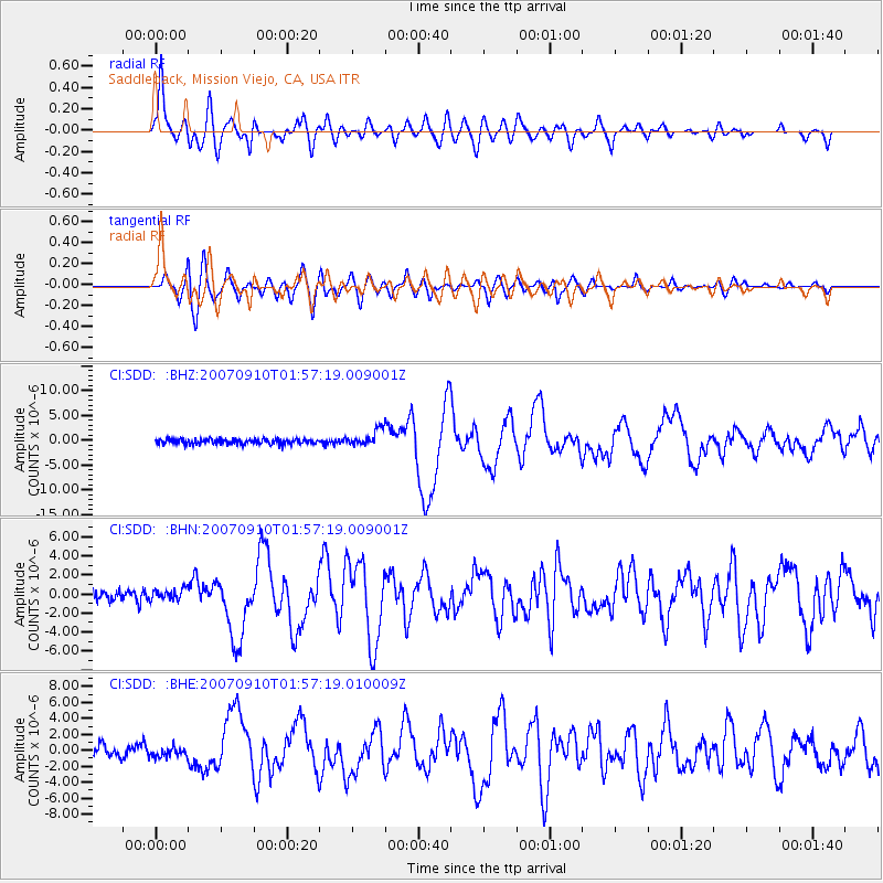
Signal To Noise
| Channel | StoN | STA | LTA |
| CI:SDD: :BHN:20070910T01:57:19.009001Z | 0.93063563 | 5.7244506E-7 | 6.151119E-7 |
| CI:SDD: :BHE:20070910T01:57:19.010009Z | 0.82948375 | 5.82181E-7 | 7.0185945E-7 |
| CI:SDD: :BHZ:20070910T01:57:19.009001Z | 3.2758434 | 1.645234E-6 | 5.022322E-7 |
| Arrivals |
| Ps | 1.1 SECOND |
| PpPs | 4.3 SECOND |
| PsPs/PpSs | 5.4 SECOND |


