You are here: Home > Network List > SS - SINGLE STATION Stations List
> Station COI COIMBRA, PORTUGAL > Earthquake Result Viewer
COI COIMBRA, PORTUGAL - Earthquake Result Viewer
| Earthquake location: |
Peru-Brazil Border Region |
| Earthquake latitude/longitude: |
-10.0/-71.0 |
| Earthquake time(UTC): |
2016/12/18 (353) 13:30:11 GMT |
| Earthquake Depth: |
619 km |
| Earthquake Magnitude: |
6.4 Mww |
| Earthquake Catalog/Contributor: |
NEIC PDE/us |
|
| Network: |
SS SINGLE STATION |
| Station: |
COI COIMBRA, PORTUGAL |
| Lat/Lon: |
40.21 N/8.41 W |
| Elevation: |
140 m |
|
| Distance: |
76.3 deg |
| Az: |
44.394 deg |
| Baz: |
244.142 deg |
| Ray Param: |
0.049082767 |
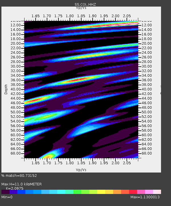
| Estimated Moho Depth: |
11.0 km |
| Estimated Crust Vp/Vs: |
2.10 |
| Assumed Crust Vp: |
6.472 km/s |
| Estimated Crust Vs: |
3.086 km/s |
| Estimated Crust Poisson's Ratio: |
0.35 |
|
| Radial Match: |
80.73152 % |
| Radial Bump: |
400 |
| Transverse Match: |
67.798004 % |
| Transverse Bump: |
400 |
| SOD ConfigId: |
11737051 |
| Insert Time: |
2019-04-26 09:11:49.480 +0000 |
| GWidth: |
2.5 |
| Max Bumps: |
400 |
| Tol: |
0.001 |
|

Signal To Noise
| Channel | StoN | STA | LTA |
| SS:COI: :HHZ:20161218T13:40:26.768003Z | 9.351033 | 2.4159913E-6 | 2.5836624E-7 |
| SS:COI: :HHN:20161218T13:40:26.768003Z | 0.87041515 | 3.705157E-7 | 4.2567697E-7 |
| SS:COI: :HHE:20161218T13:40:26.768003Z | 1.6090393 | 6.805231E-7 | 4.2293755E-7 |
| Arrivals |
| Ps | 1.9 SECOND |
| PpPs | 5.1 SECOND |
| PsPs/PpSs | 7.0 SECOND |


