You are here: Home > Network List > CI - Caltech Regional Seismic Network Stations List
> Station BEL Belle Mtn, Joshua Tree National Park, CA, USA > Earthquake Result Viewer
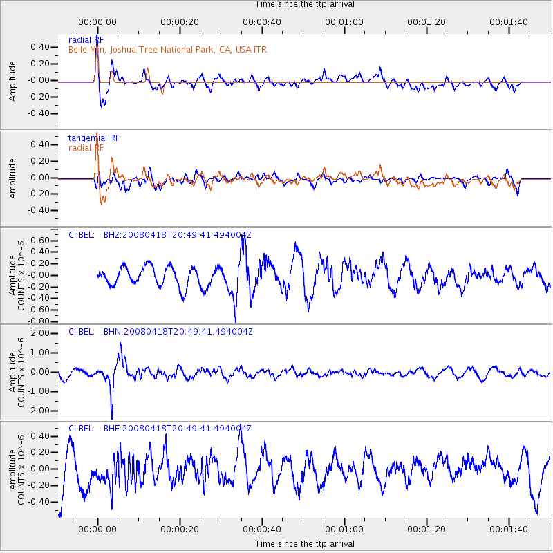
BEL Belle Mtn, Joshua Tree National Park, CA, USA - Earthquake Result Viewer
*The percent match for this event was below the threshold and hence no stack was calculated.
| Earthquake location: |
Fiji Islands Region |
| Earthquake latitude/longitude: |
-17.3/-179.0 |
| Earthquake time(UTC): |
2008/04/18 (109) 20:39:07 GMT |
| Earthquake Depth: |
554 km |
| Earthquake Magnitude: |
5.9 MB, 6.3 MW, 6.3 MW |
| Earthquake Catalog/Contributor: |
WHDF/NEIC |
|
| Network: |
CI Caltech Regional Seismic Network |
| Station: |
BEL Belle Mtn, Joshua Tree National Park, CA, USA |
| Lat/Lon: |
34.00 N/116.00 W |
| Elevation: |
1388 m |
|
| Distance: |
78.8 deg |
| Az: |
49.014 deg |
| Baz: |
240.21 deg |
| Ray Param: |
$rayparam |
*The percent match for this event was below the threshold and hence was not used in the summary stack. |
|
| Radial Match: |
68.82626 % |
| Radial Bump: |
400 |
| Transverse Match: |
45.838676 % |
| Transverse Bump: |
400 |
| SOD ConfigId: |
2504 |
| Insert Time: |
2010-03-05 20:44:51.744 +0000 |
| GWidth: |
2.5 |
| Max Bumps: |
400 |
| Tol: |
0.001 |
|
Signal To Noise
| Channel | StoN | STA | LTA |
| CI:BEL: :BHN:20080418T20:49:41.494004Z | 3.2524455 | 6.762139E-7 | 2.079094E-7 |
| CI:BEL: :BHE:20080418T20:49:41.494004Z | 0.6237967 | 1.8839354E-7 | 3.0201113E-7 |
| CI:BEL: :BHZ:20080418T20:49:41.494004Z | 1.9009235 | 3.0696282E-7 | 1.6148088E-7 |
| Arrivals |
| Ps | |
| PpPs | |
| PsPs/PpSs | |


