You are here: Home > Network List > TA - USArray Transportable Network (new EarthScope stations) Stations List
> Station G23K Bananza Creek, AK, USA > Earthquake Result Viewer
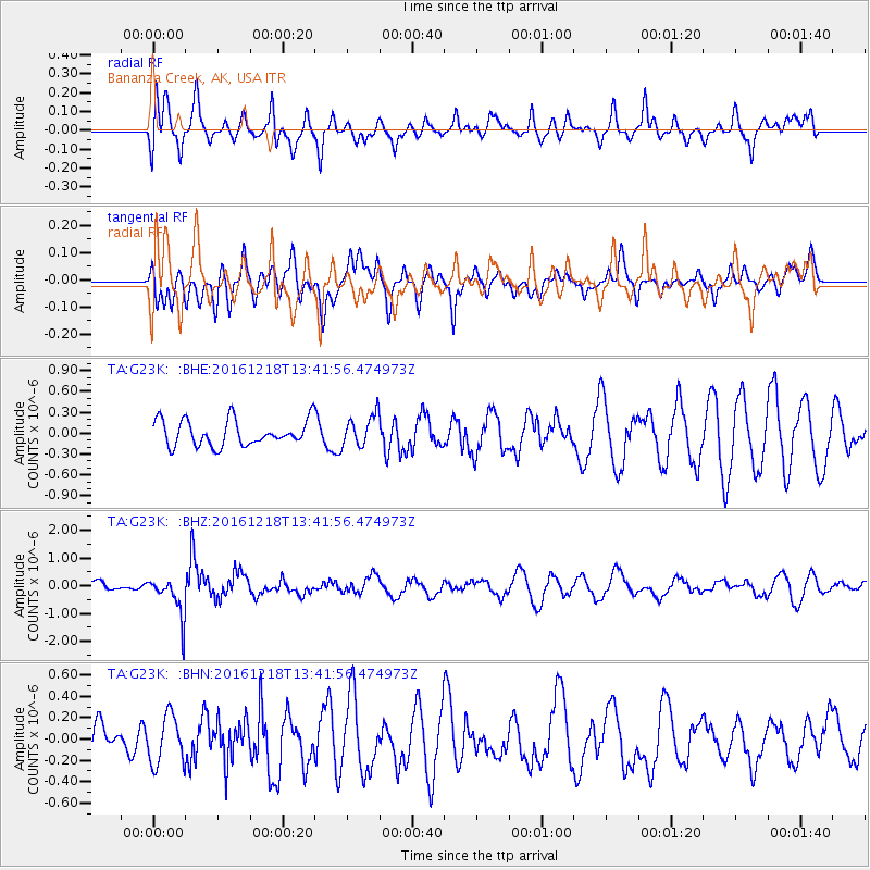
G23K Bananza Creek, AK, USA - Earthquake Result Viewer
*The percent match for this event was below the threshold and hence no stack was calculated.
| Earthquake location: |
Peru-Brazil Border Region |
| Earthquake latitude/longitude: |
-10.0/-71.0 |
| Earthquake time(UTC): |
2016/12/18 (353) 13:30:11 GMT |
| Earthquake Depth: |
619 km |
| Earthquake Magnitude: |
6.4 Mww |
| Earthquake Catalog/Contributor: |
NEIC PDE/us |
|
| Network: |
TA USArray Transportable Network (new EarthScope stations) |
| Station: |
G23K Bananza Creek, AK, USA |
| Lat/Lon: |
66.71 N/150.02 W |
| Elevation: |
746 m |
|
| Distance: |
94.8 deg |
| Az: |
336.936 deg |
| Baz: |
103.934 deg |
| Ray Param: |
$rayparam |
*The percent match for this event was below the threshold and hence was not used in the summary stack. |
|
| Radial Match: |
64.968185 % |
| Radial Bump: |
400 |
| Transverse Match: |
52.590054 % |
| Transverse Bump: |
400 |
| SOD ConfigId: |
11737051 |
| Insert Time: |
2019-04-26 09:12:10.768 +0000 |
| GWidth: |
2.5 |
| Max Bumps: |
400 |
| Tol: |
0.001 |
|
Signal To Noise
| Channel | StoN | STA | LTA |
| TA:G23K: :BHZ:20161218T13:41:56.474973Z | 2.4005036 | 7.2640825E-7 | 3.026066E-7 |
| TA:G23K: :BHN:20161218T13:41:56.474973Z | 1.1129341 | 2.2811707E-7 | 2.0496907E-7 |
| TA:G23K: :BHE:20161218T13:41:56.474973Z | 1.2022071 | 2.2368266E-7 | 1.8606E-7 |
| Arrivals |
| Ps | |
| PpPs | |
| PsPs/PpSs | |


