You are here: Home > Network List > TA - USArray Transportable Network (new EarthScope stations) Stations List
> Station L20K Farewell, AK, USA > Earthquake Result Viewer
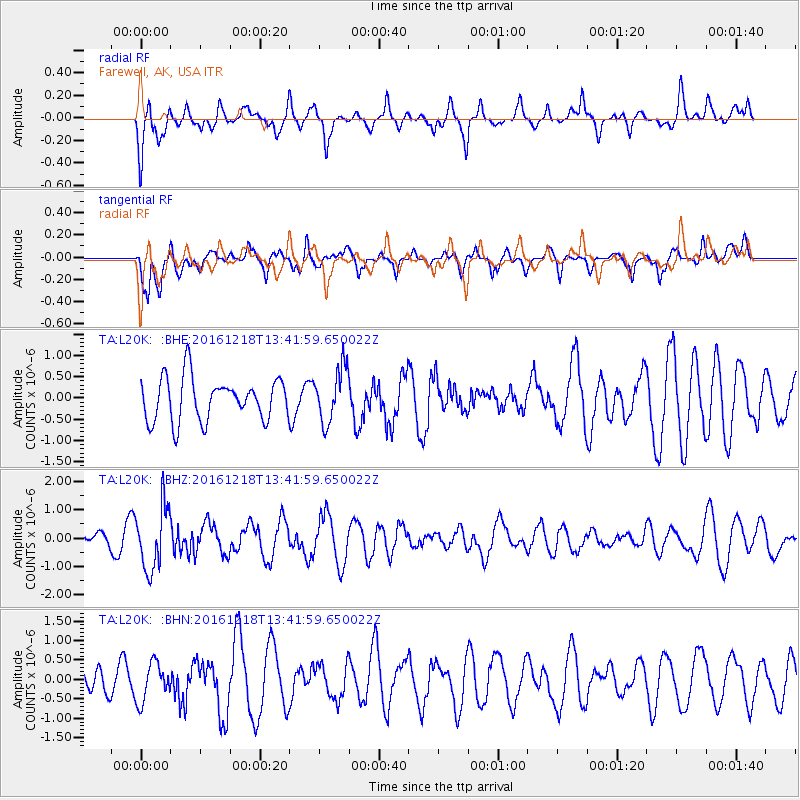
L20K Farewell, AK, USA - Earthquake Result Viewer
*The percent match for this event was below the threshold and hence no stack was calculated.
| Earthquake location: |
Peru-Brazil Border Region |
| Earthquake latitude/longitude: |
-10.0/-71.0 |
| Earthquake time(UTC): |
2016/12/18 (353) 13:30:11 GMT |
| Earthquake Depth: |
619 km |
| Earthquake Magnitude: |
6.4 Mww |
| Earthquake Catalog/Contributor: |
NEIC PDE/us |
|
| Network: |
TA USArray Transportable Network (new EarthScope stations) |
| Station: |
L20K Farewell, AK, USA |
| Lat/Lon: |
62.48 N/153.88 W |
| Elevation: |
673 m |
|
| Distance: |
95.5 deg |
| Az: |
332.412 deg |
| Baz: |
100.858 deg |
| Ray Param: |
$rayparam |
*The percent match for this event was below the threshold and hence was not used in the summary stack. |
|
| Radial Match: |
58.2715 % |
| Radial Bump: |
400 |
| Transverse Match: |
68.73617 % |
| Transverse Bump: |
400 |
| SOD ConfigId: |
11737051 |
| Insert Time: |
2019-04-26 09:12:24.227 +0000 |
| GWidth: |
2.5 |
| Max Bumps: |
400 |
| Tol: |
0.001 |
|
Signal To Noise
| Channel | StoN | STA | LTA |
| TA:L20K: :BHZ:20161218T13:41:59.650022Z | 2.9479175 | 1.1102968E-6 | 3.7663767E-7 |
| TA:L20K: :BHN:20161218T13:41:59.650022Z | 1.1677327 | 4.9117267E-7 | 4.206208E-7 |
| TA:L20K: :BHE:20161218T13:41:59.650022Z | 1.280709 | 6.4503826E-7 | 5.036572E-7 |
| Arrivals |
| Ps | |
| PpPs | |
| PsPs/PpSs | |


