You are here: Home > Network List > TA - USArray Transportable Network (new EarthScope stations) Stations List
> Station MSTX Muleshoe, TX, USA > Earthquake Result Viewer
MSTX Muleshoe, TX, USA - Earthquake Result Viewer
*The percent match for this event was below the threshold and hence no stack was calculated.
| Earthquake location: |
Peru-Brazil Border Region |
| Earthquake latitude/longitude: |
-10.0/-71.0 |
| Earthquake time(UTC): |
2016/12/18 (353) 13:30:11 GMT |
| Earthquake Depth: |
619 km |
| Earthquake Magnitude: |
6.4 Mww |
| Earthquake Catalog/Contributor: |
NEIC PDE/us |
|
| Network: |
TA USArray Transportable Network (new EarthScope stations) |
| Station: |
MSTX Muleshoe, TX, USA |
| Lat/Lon: |
33.97 N/102.77 W |
| Elevation: |
1167 m |
|
| Distance: |
53.1 deg |
| Az: |
326.8 deg |
| Baz: |
139.531 deg |
| Ray Param: |
$rayparam |
*The percent match for this event was below the threshold and hence was not used in the summary stack. |
|
| Radial Match: |
60.714863 % |
| Radial Bump: |
360 |
| Transverse Match: |
48.12637 % |
| Transverse Bump: |
333 |
| SOD ConfigId: |
11737051 |
| Insert Time: |
2019-04-26 09:12:36.218 +0000 |
| GWidth: |
2.5 |
| Max Bumps: |
400 |
| Tol: |
0.001 |
|
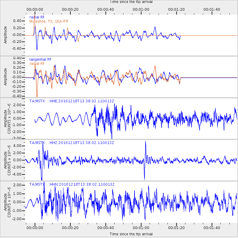
Signal To Noise
| Channel | StoN | STA | LTA |
| TA:MSTX: :HHZ:20161218T13:38:02.110013Z | 6.574794 | 2.3359105E-6 | 3.552827E-7 |
| TA:MSTX: :HHN:20161218T13:38:02.110013Z | 1.6528289 | 6.187138E-7 | 3.7433625E-7 |
| TA:MSTX: :HHE:20161218T13:38:02.110013Z | 2.0540638 | 9.1424977E-7 | 4.450932E-7 |
| Arrivals |
| Ps | |
| PpPs | |
| PsPs/PpSs | |


