You are here: Home > Network List > TA - USArray Transportable Network (new EarthScope stations) Stations List
> Station T25A Trinidad, CO, USA > Earthquake Result Viewer
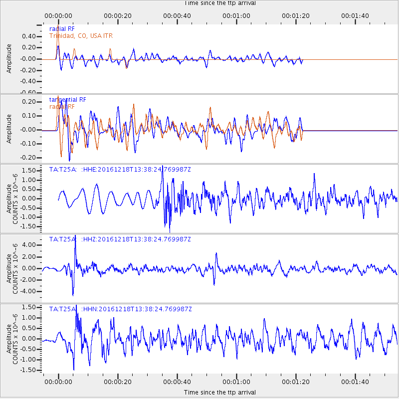
T25A Trinidad, CO, USA - Earthquake Result Viewer
*The percent match for this event was below the threshold and hence no stack was calculated.
| Earthquake location: |
Peru-Brazil Border Region |
| Earthquake latitude/longitude: |
-10.0/-71.0 |
| Earthquake time(UTC): |
2016/12/18 (353) 13:30:11 GMT |
| Earthquake Depth: |
619 km |
| Earthquake Magnitude: |
6.4 Mww |
| Earthquake Catalog/Contributor: |
NEIC PDE/us |
|
| Network: |
TA USArray Transportable Network (new EarthScope stations) |
| Station: |
T25A Trinidad, CO, USA |
| Lat/Lon: |
37.14 N/104.41 W |
| Elevation: |
2017 m |
|
| Distance: |
56.4 deg |
| Az: |
328.076 deg |
| Baz: |
139.318 deg |
| Ray Param: |
$rayparam |
*The percent match for this event was below the threshold and hence was not used in the summary stack. |
|
| Radial Match: |
47.21822 % |
| Radial Bump: |
394 |
| Transverse Match: |
64.42803 % |
| Transverse Bump: |
388 |
| SOD ConfigId: |
11737051 |
| Insert Time: |
2019-04-26 09:12:54.661 +0000 |
| GWidth: |
2.5 |
| Max Bumps: |
400 |
| Tol: |
0.001 |
|
Signal To Noise
| Channel | StoN | STA | LTA |
| TA:T25A: :HHZ:20161218T13:38:24.769987Z | 2.021725 | 8.0470903E-7 | 3.9803092E-7 |
| TA:T25A: :HHN:20161218T13:38:24.769987Z | 1.593413 | 3.2246535E-7 | 2.02374E-7 |
| TA:T25A: :HHE:20161218T13:38:24.769987Z | 0.99754184 | 3.8766638E-7 | 3.886217E-7 |
| Arrivals |
| Ps | |
| PpPs | |
| PsPs/PpSs | |


