You are here: Home > Network List > UW - Pacific Northwest Regional Seismic Network Stations List
> Station MRBL Marblemount, WA, USA > Earthquake Result Viewer
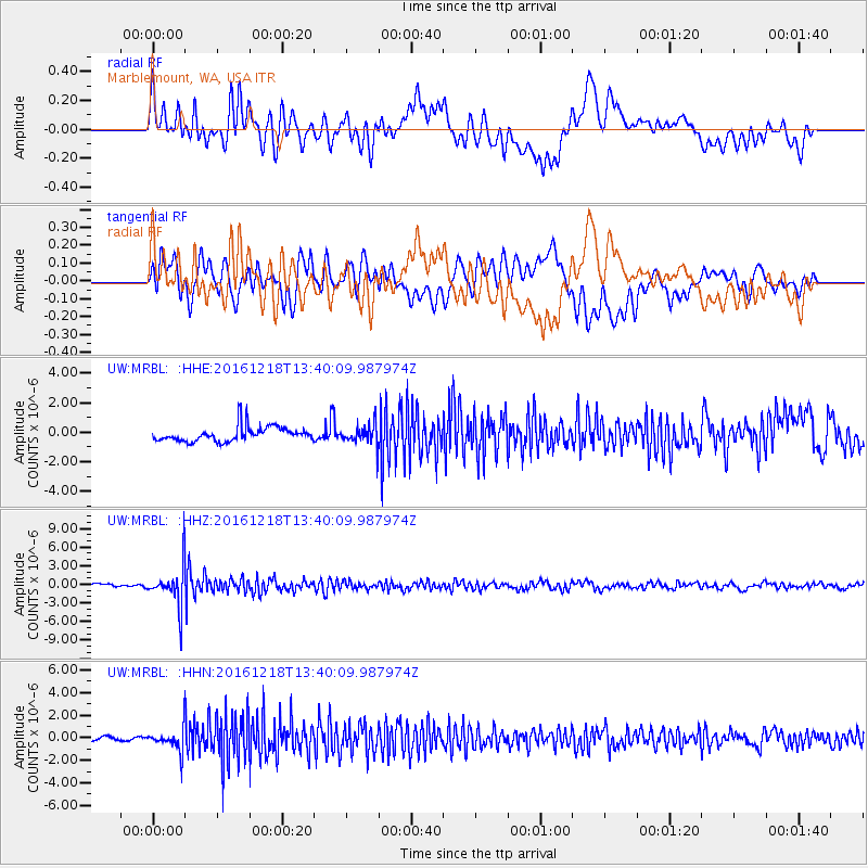
MRBL Marblemount, WA, USA - Earthquake Result Viewer
*The percent match for this event was below the threshold and hence no stack was calculated.
| Earthquake location: |
Peru-Brazil Border Region |
| Earthquake latitude/longitude: |
-10.0/-71.0 |
| Earthquake time(UTC): |
2016/12/18 (353) 13:30:11 GMT |
| Earthquake Depth: |
619 km |
| Earthquake Magnitude: |
6.4 Mww |
| Earthquake Catalog/Contributor: |
NEIC PDE/us |
|
| Network: |
UW Pacific Northwest Regional Seismic Network |
| Station: |
MRBL Marblemount, WA, USA |
| Lat/Lon: |
48.52 N/121.48 W |
| Elevation: |
75 m |
|
| Distance: |
73.3 deg |
| Az: |
327.597 deg |
| Baz: |
127.443 deg |
| Ray Param: |
$rayparam |
*The percent match for this event was below the threshold and hence was not used in the summary stack. |
|
| Radial Match: |
65.15338 % |
| Radial Bump: |
400 |
| Transverse Match: |
65.88139 % |
| Transverse Bump: |
400 |
| SOD ConfigId: |
11737051 |
| Insert Time: |
2019-04-26 09:13:46.358 +0000 |
| GWidth: |
2.5 |
| Max Bumps: |
400 |
| Tol: |
0.001 |
|
Signal To Noise
| Channel | StoN | STA | LTA |
| UW:MRBL: :HHZ:20161218T13:40:09.987974Z | 13.042335 | 3.2618277E-6 | 2.5009538E-7 |
| UW:MRBL: :HHN:20161218T13:40:09.987974Z | 4.0975857 | 9.5181656E-7 | 2.3228718E-7 |
| UW:MRBL: :HHE:20161218T13:40:09.987974Z | 1.3567255 | 6.996664E-7 | 5.157023E-7 |
| Arrivals |
| Ps | |
| PpPs | |
| PsPs/PpSs | |


