You are here: Home > Network List > YT07 - POLENET Stations List
> Station BENN BENN > Earthquake Result Viewer
BENN BENN - Earthquake Result Viewer
| Earthquake location: |
Peru-Brazil Border Region |
| Earthquake latitude/longitude: |
-10.0/-71.0 |
| Earthquake time(UTC): |
2016/12/18 (353) 13:30:11 GMT |
| Earthquake Depth: |
619 km |
| Earthquake Magnitude: |
6.4 Mww |
| Earthquake Catalog/Contributor: |
NEIC PDE/us |
|
| Network: |
YT POLENET |
| Station: |
BENN BENN |
| Lat/Lon: |
84.57 S/117.39 W |
| Elevation: |
1308 m |
|
| Distance: |
76.4 deg |
| Az: |
184.07 deg |
| Baz: |
47.258 deg |
| Ray Param: |
0.04903519 |
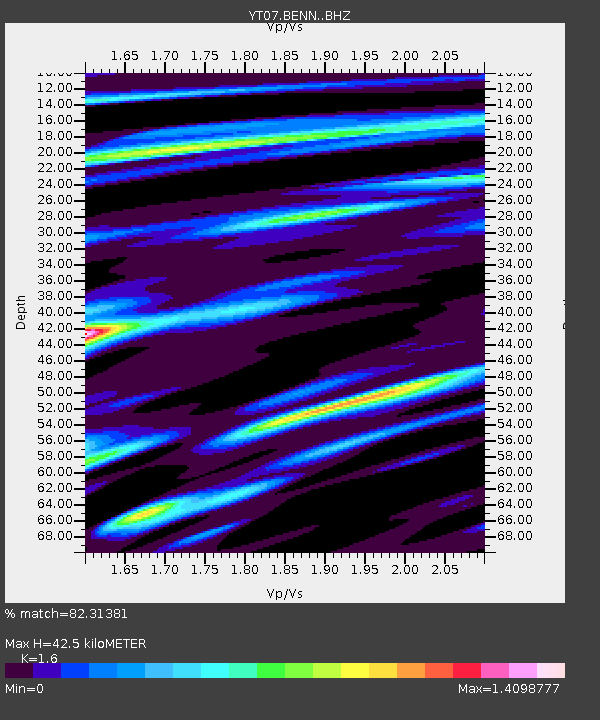
| Estimated Moho Depth: |
42.5 km |
| Estimated Crust Vp/Vs: |
1.60 |
| Assumed Crust Vp: |
6.306 km/s |
| Estimated Crust Vs: |
3.941 km/s |
| Estimated Crust Poisson's Ratio: |
0.18 |
|
| Radial Match: |
82.31381 % |
| Radial Bump: |
400 |
| Transverse Match: |
91.22697 % |
| Transverse Bump: |
400 |
| SOD ConfigId: |
11737051 |
| Insert Time: |
2019-04-26 09:15:01.282 +0000 |
| GWidth: |
2.5 |
| Max Bumps: |
400 |
| Tol: |
0.001 |
|

Signal To Noise
| Channel | StoN | STA | LTA |
| YT:BENN: :BHZ:20161218T13:40:27.198972Z | 15.810539 | 2.287236E-6 | 1.4466528E-7 |
| YT:BENN: :BHN:20161218T13:40:27.198972Z | 4.335003 | 6.7035336E-7 | 1.5463735E-7 |
| YT:BENN: :BHE:20161218T13:40:27.198972Z | 3.107556 | 5.079114E-7 | 1.63444E-7 |
| Arrivals |
| Ps | 4.2 SECOND |
| PpPs | 17 SECOND |
| PsPs/PpSs | 21 SECOND |


