You are here: Home > Network List > CI - Caltech Regional Seismic Network Stations List
> Station BEL Belle Mtn, Joshua Tree National Park, CA, USA > Earthquake Result Viewer
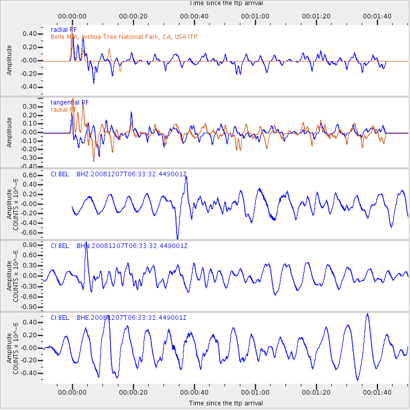
BEL Belle Mtn, Joshua Tree National Park, CA, USA - Earthquake Result Viewer
*The percent match for this event was below the threshold and hence no stack was calculated.
| Earthquake location: |
Northern Mid-Atlantic Ridge |
| Earthquake latitude/longitude: |
13.4/-44.8 |
| Earthquake time(UTC): |
2008/12/07 (342) 06:23:09 GMT |
| Earthquake Depth: |
10 km |
| Earthquake Magnitude: |
5.6 MB, 5.3 MS, 5.7 MW |
| Earthquake Catalog/Contributor: |
WHDF/NEIC |
|
| Network: |
CI Caltech Regional Seismic Network |
| Station: |
BEL Belle Mtn, Joshua Tree National Park, CA, USA |
| Lat/Lon: |
34.00 N/116.00 W |
| Elevation: |
1388 m |
|
| Distance: |
67.1 deg |
| Az: |
301.415 deg |
| Baz: |
89.02 deg |
| Ray Param: |
$rayparam |
*The percent match for this event was below the threshold and hence was not used in the summary stack. |
|
| Radial Match: |
61.10127 % |
| Radial Bump: |
400 |
| Transverse Match: |
72.63873 % |
| Transverse Bump: |
364 |
| SOD ConfigId: |
2658 |
| Insert Time: |
2010-03-05 20:45:46.296 +0000 |
| GWidth: |
2.5 |
| Max Bumps: |
400 |
| Tol: |
0.001 |
|
Signal To Noise
| Channel | StoN | STA | LTA |
| CI:BEL: :BHN:20081207T06:33:32.449001Z | 3.2589214 | 3.3416072E-7 | 1.0253722E-7 |
| CI:BEL: :BHE:20081207T06:33:32.449001Z | 2.1604936 | 1.9172577E-7 | 8.874165E-8 |
| CI:BEL: :BHZ:20081207T06:33:32.449001Z | 2.0110357 | 2.624414E-7 | 1.3050062E-7 |
| Arrivals |
| Ps | |
| PpPs | |
| PsPs/PpSs | |


