You are here: Home > Network List > CI - Caltech Regional Seismic Network Stations List
> Station BEL Belle Mtn, Joshua Tree National Park, CA, USA > Earthquake Result Viewer
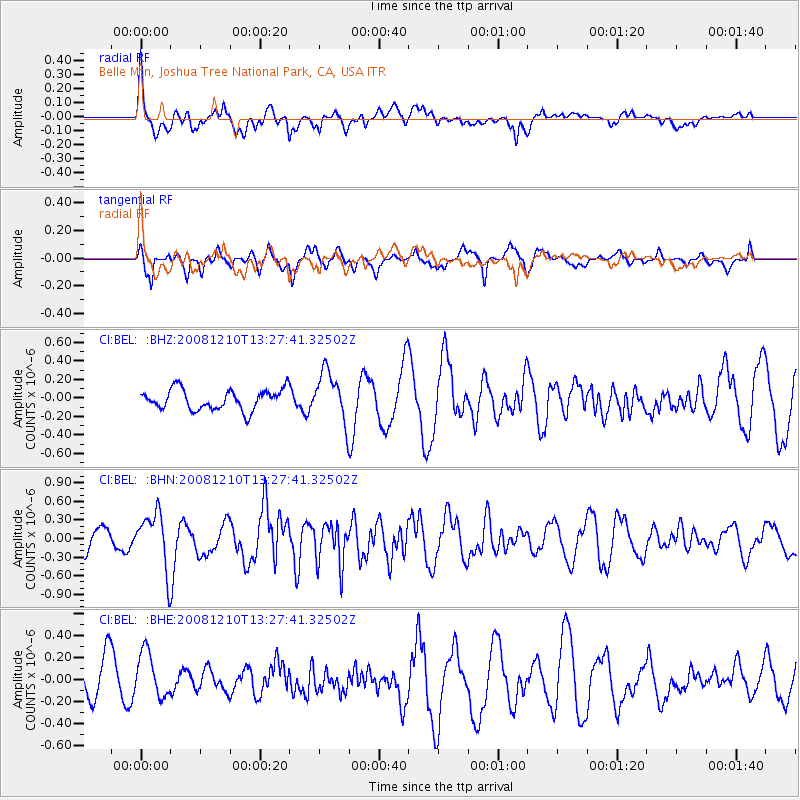
BEL Belle Mtn, Joshua Tree National Park, CA, USA - Earthquake Result Viewer
*The percent match for this event was below the threshold and hence no stack was calculated.
| Earthquake location: |
Santa Cruz Islands |
| Earthquake latitude/longitude: |
-12.3/166.6 |
| Earthquake time(UTC): |
2008/12/10 (345) 13:15:34 GMT |
| Earthquake Depth: |
51 km |
| Earthquake Magnitude: |
5.7 MB, 6.0 MW, 6.0 MW |
| Earthquake Catalog/Contributor: |
WHDF/NEIC |
|
| Network: |
CI Caltech Regional Seismic Network |
| Station: |
BEL Belle Mtn, Joshua Tree National Park, CA, USA |
| Lat/Lon: |
34.00 N/116.00 W |
| Elevation: |
1388 m |
|
| Distance: |
86.6 deg |
| Az: |
54.316 deg |
| Baz: |
252.827 deg |
| Ray Param: |
$rayparam |
*The percent match for this event was below the threshold and hence was not used in the summary stack. |
|
| Radial Match: |
78.14089 % |
| Radial Bump: |
400 |
| Transverse Match: |
47.064255 % |
| Transverse Bump: |
385 |
| SOD ConfigId: |
2658 |
| Insert Time: |
2010-03-05 20:45:49.062 +0000 |
| GWidth: |
2.5 |
| Max Bumps: |
400 |
| Tol: |
0.001 |
|
Signal To Noise
| Channel | StoN | STA | LTA |
| CI:BEL: :BHN:20081210T13:27:41.32502Z | 3.095779 | 4.4418465E-7 | 1.4348075E-7 |
| CI:BEL: :BHE:20081210T13:27:41.32502Z | 1.097266 | 2.0766086E-7 | 1.8925299E-7 |
| CI:BEL: :BHZ:20081210T13:27:41.32502Z | 2.4678848 | 2.7107723E-7 | 1.0984193E-7 |
| Arrivals |
| Ps | |
| PpPs | |
| PsPs/PpSs | |


