You are here: Home > Network List > AK - Alaska Regional Network Stations List
> Station MDM Murphy Dome > Earthquake Result Viewer
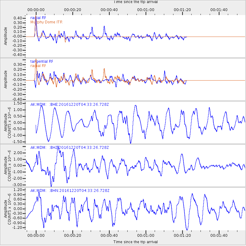
MDM Murphy Dome - Earthquake Result Viewer
*The percent match for this event was below the threshold and hence no stack was calculated.
| Earthquake location: |
Solomon Islands |
| Earthquake latitude/longitude: |
-10.2/161.2 |
| Earthquake time(UTC): |
2016/12/20 (355) 04:21:28 GMT |
| Earthquake Depth: |
11 km |
| Earthquake Magnitude: |
6.4 mww |
| Earthquake Catalog/Contributor: |
NEIC PDE/us |
|
| Network: |
AK Alaska Regional Network |
| Station: |
MDM Murphy Dome |
| Lat/Lon: |
64.96 N/148.23 W |
| Elevation: |
634 m |
|
| Distance: |
83.9 deg |
| Az: |
19.302 deg |
| Baz: |
229.859 deg |
| Ray Param: |
$rayparam |
*The percent match for this event was below the threshold and hence was not used in the summary stack. |
|
| Radial Match: |
65.14438 % |
| Radial Bump: |
400 |
| Transverse Match: |
56.650665 % |
| Transverse Bump: |
400 |
| SOD ConfigId: |
11737051 |
| Insert Time: |
2019-04-26 09:32:35.121 +0000 |
| GWidth: |
2.5 |
| Max Bumps: |
400 |
| Tol: |
0.001 |
|
Signal To Noise
| Channel | StoN | STA | LTA |
| AK:MDM: :BHZ:20161220T04:33:26.728Z | 1.3980389 | 1.0536161E-6 | 7.5363863E-7 |
| AK:MDM: :BHN:20161220T04:33:26.728Z | 1.4611372 | 7.088647E-7 | 4.851459E-7 |
| AK:MDM: :BHE:20161220T04:33:26.728Z | 0.69460917 | 5.2775636E-7 | 7.597889E-7 |
| Arrivals |
| Ps | |
| PpPs | |
| PsPs/PpSs | |


