You are here: Home > Network List > CI - Caltech Regional Seismic Network Stations List
> Station BEL Belle Mtn, Joshua Tree National Park, CA, USA > Earthquake Result Viewer
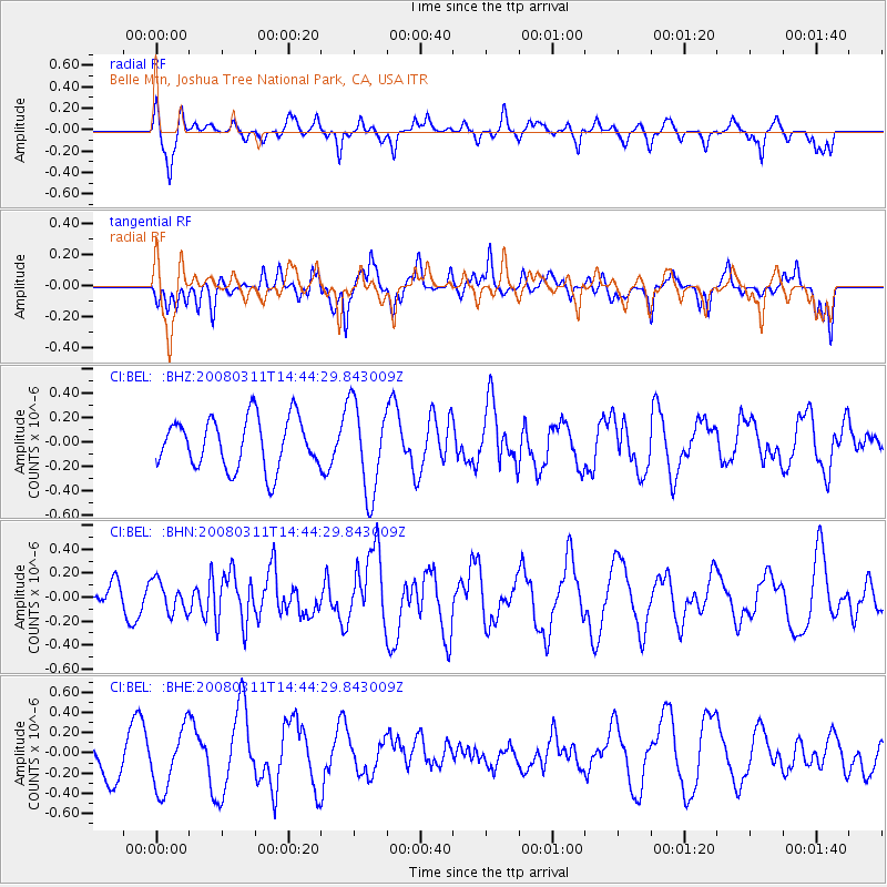
BEL Belle Mtn, Joshua Tree National Park, CA, USA - Earthquake Result Viewer
*The percent match for this event was below the threshold and hence no stack was calculated.
| Earthquake location: |
Fox Islands, Aleutian Islands |
| Earthquake latitude/longitude: |
52.2/-169.5 |
| Earthquake time(UTC): |
2008/03/11 (071) 14:37:10 GMT |
| Earthquake Depth: |
16 km |
| Earthquake Magnitude: |
5.5 MB, 5.3 MS, 5.6 MW, 5.5 MW |
| Earthquake Catalog/Contributor: |
WHDF/NEIC |
|
| Network: |
CI Caltech Regional Seismic Network |
| Station: |
BEL Belle Mtn, Joshua Tree National Park, CA, USA |
| Lat/Lon: |
34.00 N/116.00 W |
| Elevation: |
1388 m |
|
| Distance: |
42.0 deg |
| Az: |
93.998 deg |
| Baz: |
312.309 deg |
| Ray Param: |
$rayparam |
*The percent match for this event was below the threshold and hence was not used in the summary stack. |
|
| Radial Match: |
54.004814 % |
| Radial Bump: |
315 |
| Transverse Match: |
48.827774 % |
| Transverse Bump: |
330 |
| SOD ConfigId: |
2504 |
| Insert Time: |
2010-03-05 20:46:04.119 +0000 |
| GWidth: |
2.5 |
| Max Bumps: |
400 |
| Tol: |
0.001 |
|
Signal To Noise
| Channel | StoN | STA | LTA |
| CI:BEL: :BHN:20080311T14:44:29.843009Z | 1.1204382 | 1.3110238E-7 | 1.1700991E-7 |
| CI:BEL: :BHE:20080311T14:44:29.843009Z | 1.0565012 | 3.0871215E-7 | 2.9220237E-7 |
| CI:BEL: :BHZ:20080311T14:44:29.843009Z | 1.785089 | 3.6741824E-7 | 2.0582628E-7 |
| Arrivals |
| Ps | |
| PpPs | |
| PsPs/PpSs | |


