You are here: Home > Network List > TA - USArray Transportable Network (new EarthScope stations) Stations List
> Station P32M Atlin, BC, CAN > Earthquake Result Viewer
P32M Atlin, BC, CAN - Earthquake Result Viewer

| Earthquake location: |
Solomon Islands |
| Earthquake latitude/longitude: |
-10.2/161.2 |
| Earthquake time(UTC): |
2016/12/20 (355) 04:21:28 GMT |
| Earthquake Depth: |
11 km |
| Earthquake Magnitude: |
6.4 mww |
| Earthquake Catalog/Contributor: |
NEIC PDE/us |
|
| Network: |
TA USArray Transportable Network (new EarthScope stations) |
| Station: |
P32M Atlin, BC, CAN |
| Lat/Lon: |
59.59 N/133.71 W |
| Elevation: |
793 m |
|
| Distance: |
86.6 deg |
| Az: |
27.524 deg |
| Baz: |
243.4 deg |
| Ray Param: |
0.043929774 |
| Estimated Moho Depth: |
62.25 km |
| Estimated Crust Vp/Vs: |
1.62 |
| Assumed Crust Vp: |
6.597 km/s |
| Estimated Crust Vs: |
4.085 km/s |
| Estimated Crust Poisson's Ratio: |
0.19 |
|
| Radial Match: |
90.10207 % |
| Radial Bump: |
400 |
| Transverse Match: |
80.2875 % |
| Transverse Bump: |
244 |
| SOD ConfigId: |
11737051 |
| Insert Time: |
2019-04-26 09:37:43.645 +0000 |
| GWidth: |
2.5 |
| Max Bumps: |
400 |
| Tol: |
0.001 |
|
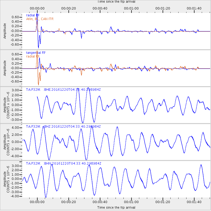
Signal To Noise
| Channel | StoN | STA | LTA |
| TA:P32M: :BHZ:20161220T04:33:40.298984Z | 1.4346328 | 2.8849518E-6 | 2.010934E-6 |
| TA:P32M: :BHN:20161220T04:33:40.298984Z | 1.1744696 | 1.912643E-6 | 1.6285164E-6 |
| TA:P32M: :BHE:20161220T04:33:40.298984Z | 2.451375 | 2.5933266E-6 | 1.057907E-6 |
| Arrivals |
| Ps | 6.0 SECOND |
| PpPs | 24 SECOND |
| PsPs/PpSs | 30 SECOND |


