You are here: Home > Network List > CI - Caltech Regional Seismic Network Stations List
> Station DVT Desert View Tower, Ocotillo, CA, USA > Earthquake Result Viewer
DVT Desert View Tower, Ocotillo, CA, USA - Earthquake Result Viewer
| Earthquake location: |
Andreanof Islands, Aleutian Is. |
| Earthquake latitude/longitude: |
51.9/-177.5 |
| Earthquake time(UTC): |
2008/05/02 (123) 01:33:37 GMT |
| Earthquake Depth: |
14 km |
| Earthquake Magnitude: |
6.3 MB, 6.8 MS, 6.6 MW, 6.6 MW |
| Earthquake Catalog/Contributor: |
WHDF/NEIC |
|
| Network: |
CI Caltech Regional Seismic Network |
| Station: |
DVT Desert View Tower, Ocotillo, CA, USA |
| Lat/Lon: |
32.66 N/116.10 W |
| Elevation: |
881 m |
|
| Distance: |
47.8 deg |
| Az: |
88.722 deg |
| Baz: |
312.699 deg |
| Ray Param: |
0.06974088 |
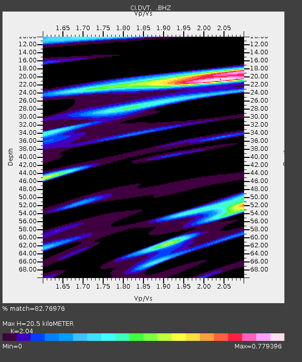
| Estimated Moho Depth: |
20.5 km |
| Estimated Crust Vp/Vs: |
2.04 |
| Assumed Crust Vp: |
6.264 km/s |
| Estimated Crust Vs: |
3.07 km/s |
| Estimated Crust Poisson's Ratio: |
0.34 |
|
| Radial Match: |
82.76976 % |
| Radial Bump: |
354 |
| Transverse Match: |
71.659355 % |
| Transverse Bump: |
400 |
| SOD ConfigId: |
2504 |
| Insert Time: |
2010-03-05 20:46:35.559 +0000 |
| GWidth: |
2.5 |
| Max Bumps: |
400 |
| Tol: |
0.001 |
|

Signal To Noise
| Channel | StoN | STA | LTA |
| CI:DVT: :BHZ:20080502T01:41:43.255991Z | 3.7179224 | 1.3493194E-6 | 3.6292295E-7 |
| CI:DVT: :BHN:20080502T01:41:43.255991Z | 1.4289501 | 6.081687E-7 | 4.2560532E-7 |
| CI:DVT: :BHE:20080502T01:41:43.255991Z | 1.0028462 | 4.3585098E-7 | 4.3461395E-7 |
| Arrivals |
| Ps | 3.6 SECOND |
| PpPs | 9.5 SECOND |
| PsPs/PpSs | 13 SECOND |


