You are here: Home > Network List > YT07 - POLENET Stations List
> Station DEVL DEVL > Earthquake Result Viewer
DEVL DEVL - Earthquake Result Viewer
| Earthquake location: |
Solomon Islands |
| Earthquake latitude/longitude: |
-10.2/161.2 |
| Earthquake time(UTC): |
2016/12/20 (355) 04:21:28 GMT |
| Earthquake Depth: |
11 km |
| Earthquake Magnitude: |
6.4 mww |
| Earthquake Catalog/Contributor: |
NEIC PDE/us |
|
| Network: |
YT POLENET |
| Station: |
DEVL DEVL |
| Lat/Lon: |
81.48 S/161.97 E |
| Elevation: |
101 m |
|
| Distance: |
71.3 deg |
| Az: |
179.881 deg |
| Baz: |
359.216 deg |
| Ray Param: |
0.05444229 |
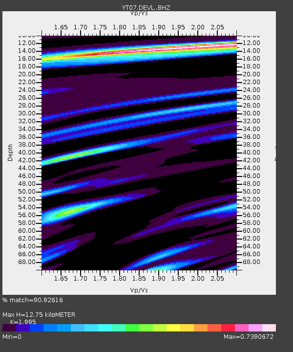
| Estimated Moho Depth: |
12.75 km |
| Estimated Crust Vp/Vs: |
2.00 |
| Assumed Crust Vp: |
6.43 km/s |
| Estimated Crust Vs: |
3.223 km/s |
| Estimated Crust Poisson's Ratio: |
0.33 |
|
| Radial Match: |
90.92616 % |
| Radial Bump: |
349 |
| Transverse Match: |
81.783264 % |
| Transverse Bump: |
400 |
| SOD ConfigId: |
11737051 |
| Insert Time: |
2019-04-26 09:39:01.687 +0000 |
| GWidth: |
2.5 |
| Max Bumps: |
400 |
| Tol: |
0.001 |
|

Signal To Noise
| Channel | StoN | STA | LTA |
| YT:DEVL: :BHZ:20161220T04:32:16.473972Z | 15.336991 | 1.1816577E-6 | 7.704625E-8 |
| YT:DEVL: :BHN:20161220T04:32:16.473972Z | 6.207421 | 5.9376447E-7 | 9.565397E-8 |
| YT:DEVL: :BHE:20161220T04:32:16.473972Z | 3.4658856 | 2.3185723E-7 | 6.6896966E-8 |
| Arrivals |
| Ps | 2.0 SECOND |
| PpPs | 5.8 SECOND |
| PsPs/PpSs | 7.8 SECOND |


