You are here: Home > Network List > YT07 - POLENET Stations List
> Station MA03 Polenet mini-array MA03 > Earthquake Result Viewer
MA03 Polenet mini-array MA03 - Earthquake Result Viewer
| Earthquake location: |
Solomon Islands |
| Earthquake latitude/longitude: |
-10.2/161.2 |
| Earthquake time(UTC): |
2016/12/20 (355) 04:21:28 GMT |
| Earthquake Depth: |
11 km |
| Earthquake Magnitude: |
6.4 mww |
| Earthquake Catalog/Contributor: |
NEIC PDE/us |
|
| Network: |
YT POLENET |
| Station: |
MA03 Polenet mini-array MA03 |
| Lat/Lon: |
77.94 S/97.56 W |
| Elevation: |
1622 m |
|
| Distance: |
82.4 deg |
| Az: |
167.99 deg |
| Baz: |
256.917 deg |
| Ray Param: |
0.04690662 |
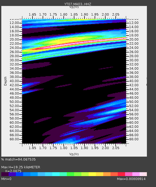
| Estimated Moho Depth: |
19.25 km |
| Estimated Crust Vp/Vs: |
2.09 |
| Assumed Crust Vp: |
5.77 km/s |
| Estimated Crust Vs: |
2.764 km/s |
| Estimated Crust Poisson's Ratio: |
0.35 |
|
| Radial Match: |
94.067535 % |
| Radial Bump: |
374 |
| Transverse Match: |
86.86316 % |
| Transverse Bump: |
400 |
| SOD ConfigId: |
11737051 |
| Insert Time: |
2019-04-26 09:39:08.681 +0000 |
| GWidth: |
2.5 |
| Max Bumps: |
400 |
| Tol: |
0.001 |
|

Signal To Noise
| Channel | StoN | STA | LTA |
| YT:MA03: :HHZ:20161220T04:33:19.129001Z | 5.7354474 | 1.0710589E-6 | 1.8674373E-7 |
| YT:MA03: :HHN:20161220T04:33:19.129001Z | 1.995571 | 9.772406E-8 | 4.8970477E-8 |
| YT:MA03: :HHE:20161220T04:33:19.129001Z | 4.7898583 | 4.671975E-7 | 9.75389E-8 |
| Arrivals |
| Ps | 3.7 SECOND |
| PpPs | 10 SECOND |
| PsPs/PpSs | 14 SECOND |


