You are here: Home > Network List > CI - Caltech Regional Seismic Network Stations List
> Station DVT Desert View Tower, Ocotillo, CA, USA > Earthquake Result Viewer
DVT Desert View Tower, Ocotillo, CA, USA - Earthquake Result Viewer
| Earthquake location: |
South Of Fiji Islands |
| Earthquake latitude/longitude: |
-26.0/-177.5 |
| Earthquake time(UTC): |
2007/12/09 (343) 07:28:20 GMT |
| Earthquake Depth: |
152 km |
| Earthquake Magnitude: |
7.0 MB, 7.8 MW, 7.7 MW |
| Earthquake Catalog/Contributor: |
WHDF/NEIC |
|
| Network: |
CI Caltech Regional Seismic Network |
| Station: |
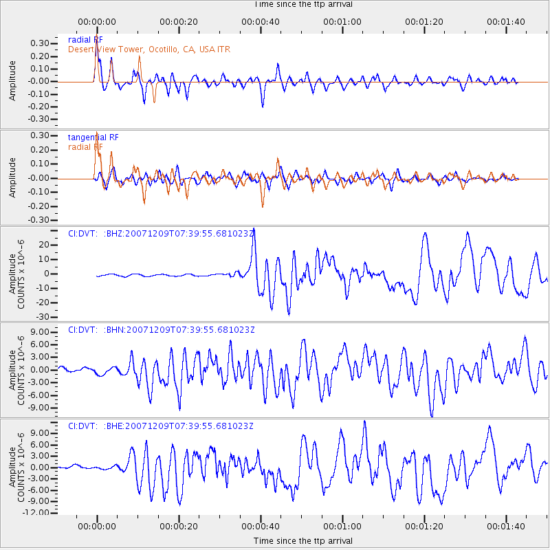
DVT Desert View Tower, Ocotillo, CA, USA |
| Lat/Lon: |
32.66 N/116.10 W |
| Elevation: |
881 m |
|
| Distance: |
82.6 deg |
| Az: |
48.328 deg |
| Baz: |
232.839 deg |
| Ray Param: |
0.0464343 |
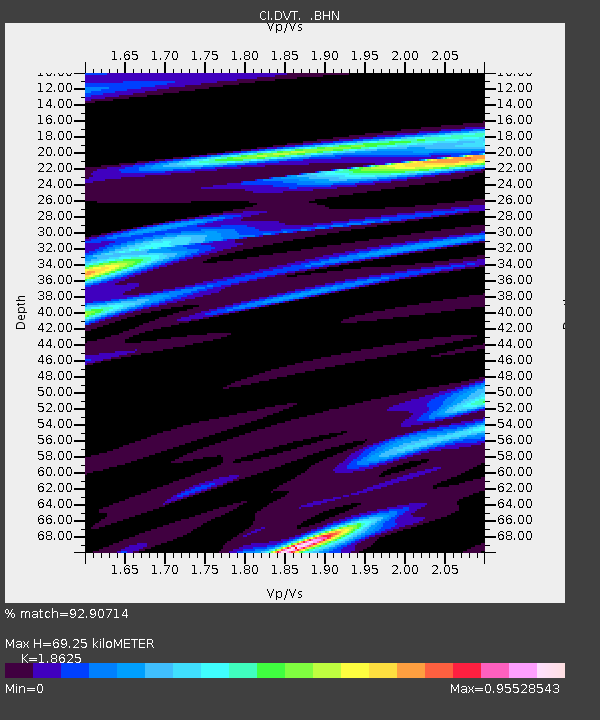
| Estimated Moho Depth: |
69.25 km |
| Estimated Crust Vp/Vs: |
1.86 |
| Assumed Crust Vp: |
6.264 km/s |
| Estimated Crust Vs: |
3.363 km/s |
| Estimated Crust Poisson's Ratio: |
0.30 |
|
| Radial Match: |
92.90714 % |
| Radial Bump: |
400 |
| Transverse Match: |
81.91537 % |
| Transverse Bump: |
400 |
| SOD ConfigId: |
2564 |
| Insert Time: |
2010-03-05 20:47:53.187 +0000 |
| GWidth: |
2.5 |
| Max Bumps: |
400 |
| Tol: |
0.001 |
|
Signal To Noise
| Channel | StoN | STA | LTA |
| CI:DVT: :BHN:20071209T07:39:55.681023Z | 1.0793328 | 8.2116406E-7 | 7.608071E-7 |
| CI:DVT: :BHE:20071209T07:39:55.681023Z | 0.6983341 | 4.2159252E-7 | 6.037118E-7 |
| CI:DVT: :BHZ:20071209T07:39:55.681023Z | 1.9546162 | 1.3191072E-6 | 6.7486764E-7 |
| Arrivals |
| Ps | 9.8 SECOND |
| PpPs | 31 SECOND |
| PsPs/PpSs | 41 SECOND |


