You are here: Home > Network List > CI - Caltech Regional Seismic Network Stations List
> Station DAN Danby, California, USA > Earthquake Result Viewer
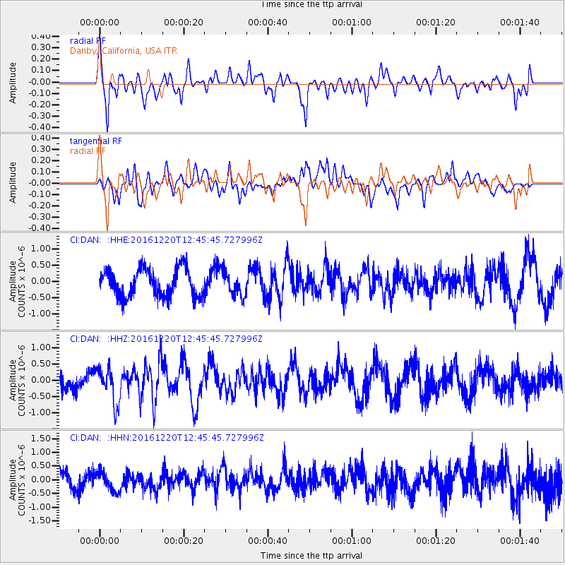
DAN Danby, California, USA - Earthquake Result Viewer
*The percent match for this event was below the threshold and hence no stack was calculated.
| Earthquake location: |
Solomon Islands |
| Earthquake latitude/longitude: |
-10.2/160.9 |
| Earthquake time(UTC): |
2016/12/20 (355) 12:33:15 GMT |
| Earthquake Depth: |
12 km |
| Earthquake Magnitude: |
5.9 mb |
| Earthquake Catalog/Contributor: |
NEIC PDE/us |
|
| Network: |
CI Caltech Regional Seismic Network |
| Station: |
DAN Danby, California, USA |
| Lat/Lon: |
34.64 N/115.38 W |
| Elevation: |
398 m |
|
| Distance: |
90.6 deg |
| Az: |
55.045 deg |
| Baz: |
258.137 deg |
| Ray Param: |
$rayparam |
*The percent match for this event was below the threshold and hence was not used in the summary stack. |
|
| Radial Match: |
51.626694 % |
| Radial Bump: |
400 |
| Transverse Match: |
62.242256 % |
| Transverse Bump: |
400 |
| SOD ConfigId: |
11737051 |
| Insert Time: |
2019-04-26 09:54:27.367 +0000 |
| GWidth: |
2.5 |
| Max Bumps: |
400 |
| Tol: |
0.001 |
|
Signal To Noise
| Channel | StoN | STA | LTA |
| CI:DAN: :HHZ:20161220T12:45:45.727996Z | 2.2677565 | 5.6347E-7 | 2.4847023E-7 |
| CI:DAN: :HHN:20161220T12:45:45.727996Z | 1.2079443 | 3.669015E-7 | 3.0374042E-7 |
| CI:DAN: :HHE:20161220T12:45:45.727996Z | 0.8486922 | 3.6822368E-7 | 4.3387192E-7 |
| Arrivals |
| Ps | |
| PpPs | |
| PsPs/PpSs | |


