You are here: Home > Network List > CI - Caltech Regional Seismic Network Stations List
> Station DVT Desert View Tower, Ocotillo, CA, USA > Earthquake Result Viewer
DVT Desert View Tower, Ocotillo, CA, USA - Earthquake Result Viewer

| Earthquake location: |
Tonga Islands Region |
| Earthquake latitude/longitude: |
-23.0/-174.7 |
| Earthquake time(UTC): |
2009/03/19 (078) 18:17:40 GMT |
| Earthquake Depth: |
34 km |
| Earthquake Magnitude: |
7.0 MB, 7.6 MS, 7.6 MW, 7.6 MW |
| Earthquake Catalog/Contributor: |
WHDF/NEIC |
|
| Network: |
CI Caltech Regional Seismic Network |
| Station: |
DVT Desert View Tower, Ocotillo, CA, USA |
| Lat/Lon: |
32.66 N/116.10 W |
| Elevation: |
881 m |
|
| Distance: |
78.7 deg |
| Az: |
47.219 deg |
| Baz: |
233.271 deg |
| Ray Param: |
0.04942842 |
| Estimated Moho Depth: |
69.75 km |
| Estimated Crust Vp/Vs: |
1.84 |
| Assumed Crust Vp: |
6.264 km/s |
| Estimated Crust Vs: |
3.413 km/s |
| Estimated Crust Poisson's Ratio: |
0.29 |
|
| Radial Match: |
96.35981 % |
| Radial Bump: |
400 |
| Transverse Match: |
85.46737 % |
| Transverse Bump: |
400 |
| SOD ConfigId: |
2658 |
| Insert Time: |
2010-03-05 20:48:09.539 +0000 |
| GWidth: |
2.5 |
| Max Bumps: |
400 |
| Tol: |
0.001 |
|
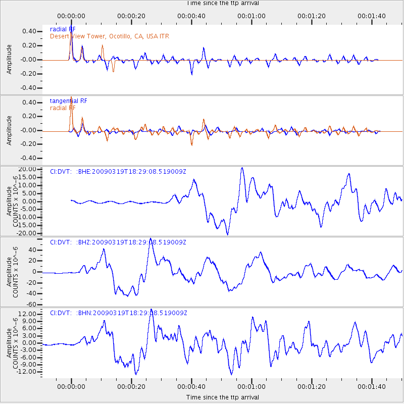
Signal To Noise
| Channel | StoN | STA | LTA |
| CI:DVT: :BHZ:20090319T18:29:08.519009Z | 12.625314 | 5.990197E-6 | 4.7445928E-7 |
| CI:DVT: :BHN:20090319T18:29:08.519009Z | 4.3076677 | 1.434914E-6 | 3.3310695E-7 |
| CI:DVT: :BHE:20090319T18:29:08.519009Z | 3.6732605 | 2.0913865E-6 | 5.6935426E-7 |
| Arrivals |
| Ps | 9.6 SECOND |
| PpPs | 31 SECOND |
| PsPs/PpSs | 40 SECOND |


