You are here: Home > Network List > CI - Caltech Regional Seismic Network Stations List
> Station DVT Desert View Tower, Ocotillo, CA, USA > Earthquake Result Viewer
DVT Desert View Tower, Ocotillo, CA, USA - Earthquake Result Viewer
| Earthquake location: |
East Of Kuril Islands |
| Earthquake latitude/longitude: |
46.2/154.4 |
| Earthquake time(UTC): |
2006/12/07 (341) 19:10:21 GMT |
| Earthquake Depth: |
16 km |
| Earthquake Magnitude: |
6.3 MB, 6.1 MS, 6.3 MW, 6.3 MW |
| Earthquake Catalog/Contributor: |
WHDF/NEIC |
|
| Network: |
CI Caltech Regional Seismic Network |
| Station: |
DVT Desert View Tower, Ocotillo, CA, USA |
| Lat/Lon: |
32.66 N/116.10 W |
| Elevation: |
881 m |
|
| Distance: |
67.0 deg |
| Az: |
66.418 deg |
| Baz: |
310.951 deg |
| Ray Param: |
0.057243496 |
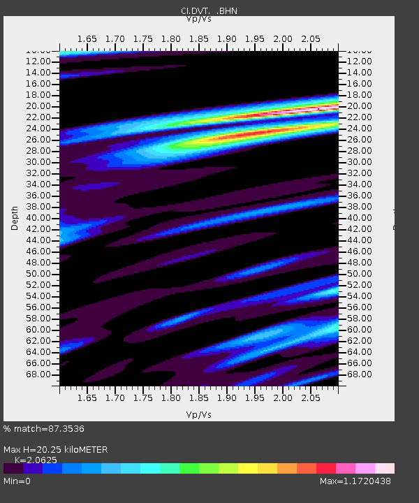
| Estimated Moho Depth: |
20.25 km |
| Estimated Crust Vp/Vs: |
2.06 |
| Assumed Crust Vp: |
6.264 km/s |
| Estimated Crust Vs: |
3.037 km/s |
| Estimated Crust Poisson's Ratio: |
0.35 |
|
| Radial Match: |
87.3536 % |
| Radial Bump: |
400 |
| Transverse Match: |
54.72905 % |
| Transverse Bump: |
400 |
| SOD ConfigId: |
2564 |
| Insert Time: |
2010-03-05 20:48:13.336 +0000 |
| GWidth: |
2.5 |
| Max Bumps: |
400 |
| Tol: |
0.001 |
|

Signal To Noise
| Channel | StoN | STA | LTA |
| CI:DVT: :BHN:20061207T19:20:42.506006Z | 1.3581734 | 5.49928E-7 | 4.0490266E-7 |
| CI:DVT: :BHE:20061207T19:20:42.506006Z | 1.1332872 | 4.736542E-7 | 4.179472E-7 |
| CI:DVT: :BHZ:20061207T19:20:42.506006Z | 4.0610533 | 7.211376E-7 | 1.7757404E-7 |
| Arrivals |
| Ps | 3.5 SECOND |
| PpPs | 9.6 SECOND |
| PsPs/PpSs | 13 SECOND |


