You are here: Home > Network List > CI - Caltech Regional Seismic Network Stations List
> Station DVT Desert View Tower, Ocotillo, CA, USA > Earthquake Result Viewer
DVT Desert View Tower, Ocotillo, CA, USA - Earthquake Result Viewer
| Earthquake location: |
Kuril Islands |
| Earthquake latitude/longitude: |
46.6/153.3 |
| Earthquake time(UTC): |
2006/11/15 (319) 11:14:13 GMT |
| Earthquake Depth: |
10 km |
| Earthquake Magnitude: |
6.5 MB, 7.8 MS, 8.3 MW, 7.9 MW |
| Earthquake Catalog/Contributor: |
WHDF/NEIC |
|
| Network: |
CI Caltech Regional Seismic Network |
| Station: |
DVT Desert View Tower, Ocotillo, CA, USA |
| Lat/Lon: |
32.66 N/116.10 W |
| Elevation: |
881 m |
|
| Distance: |
67.5 deg |
| Az: |
65.91 deg |
| Baz: |
311.726 deg |
| Ray Param: |
0.056908637 |
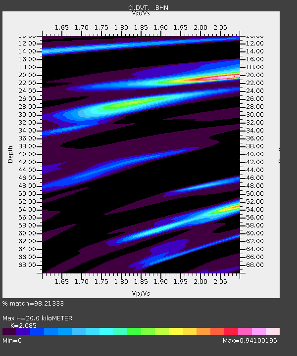
| Estimated Moho Depth: |
20.0 km |
| Estimated Crust Vp/Vs: |
2.09 |
| Assumed Crust Vp: |
6.264 km/s |
| Estimated Crust Vs: |
3.004 km/s |
| Estimated Crust Poisson's Ratio: |
0.35 |
|
| Radial Match: |
98.21333 % |
| Radial Bump: |
233 |
| Transverse Match: |
89.43736 % |
| Transverse Bump: |
400 |
| SOD ConfigId: |
2564 |
| Insert Time: |
2010-03-05 20:48:17.840 +0000 |
| GWidth: |
2.5 |
| Max Bumps: |
400 |
| Tol: |
0.001 |
|
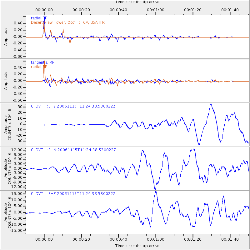
Signal To Noise
| Channel | StoN | STA | LTA |
| CI:DVT: :BHN:20061115T11:24:38.530022Z | 1.2707132 | 5.712298E-7 | 4.4953478E-7 |
| CI:DVT: :BHE:20061115T11:24:38.530022Z | 0.9945751 | 3.3657054E-7 | 3.3840635E-7 |
| CI:DVT: :BHZ:20061115T11:24:38.530022Z | 2.5214438 | 1.3950632E-6 | 5.532795E-7 |
| Arrivals |
| Ps | 3.6 SECOND |
| PpPs | 9.5 SECOND |
| PsPs/PpSs | 13 SECOND |


