You are here: Home > Network List > CI - Caltech Regional Seismic Network Stations List
> Station DVT Desert View Tower, Ocotillo, CA, USA > Earthquake Result Viewer
DVT Desert View Tower, Ocotillo, CA, USA - Earthquake Result Viewer
| Earthquake location: |
Fiji Islands Region |
| Earthquake latitude/longitude: |
-19.9/-178.2 |
| Earthquake time(UTC): |
2006/01/02 (002) 22:13:40 GMT |
| Earthquake Depth: |
583 km |
| Earthquake Magnitude: |
6.5 MB, 7.2 MW, 7.1 MW |
| Earthquake Catalog/Contributor: |
WHDF/NEIC |
|
| Network: |
CI Caltech Regional Seismic Network |
| Station: |
DVT Desert View Tower, Ocotillo, CA, USA |
| Lat/Lon: |
32.66 N/116.10 W |
| Elevation: |
881 m |
|
| Distance: |
79.1 deg |
| Az: |
49.386 deg |
| Baz: |
237.855 deg |
| Ray Param: |
0.047409244 |
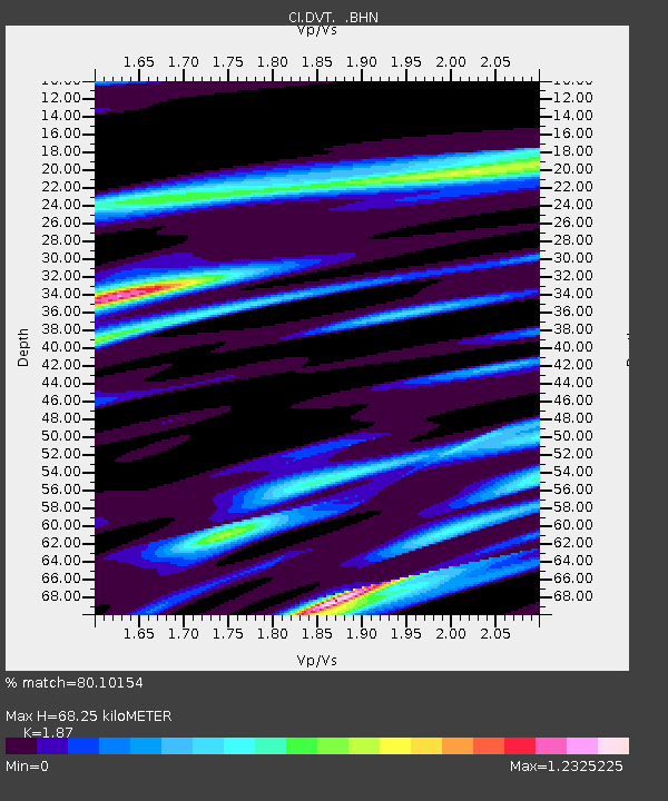
| Estimated Moho Depth: |
68.25 km |
| Estimated Crust Vp/Vs: |
1.87 |
| Assumed Crust Vp: |
6.264 km/s |
| Estimated Crust Vs: |
3.35 km/s |
| Estimated Crust Poisson's Ratio: |
0.30 |
|
| Radial Match: |
80.10154 % |
| Radial Bump: |
400 |
| Transverse Match: |
79.52239 % |
| Transverse Bump: |
400 |
| SOD ConfigId: |
2422 |
| Insert Time: |
2010-03-05 20:48:49.294 +0000 |
| GWidth: |
2.5 |
| Max Bumps: |
400 |
| Tol: |
0.001 |
|

Signal To Noise
| Channel | StoN | STA | LTA |
| CI:DVT: :BHN:20060102T22:24:14.010996Z | 3.1766834 | 1.2775328E-6 | 4.021593E-7 |
| CI:DVT: :BHE:20060102T22:24:14.010996Z | 2.969294 | 1.6178948E-6 | 5.4487526E-7 |
| CI:DVT: :BHZ:20060102T22:24:14.010996Z | 13.233646 | 6.9276225E-6 | 5.2348554E-7 |
| Arrivals |
| Ps | 9.7 SECOND |
| PpPs | 31 SECOND |
| PsPs/PpSs | 40 SECOND |


