You are here: Home > Network List > UW - Pacific Northwest Regional Seismic Network Stations List
> Station LON Longmire CREST broad-band > Earthquake Result Viewer
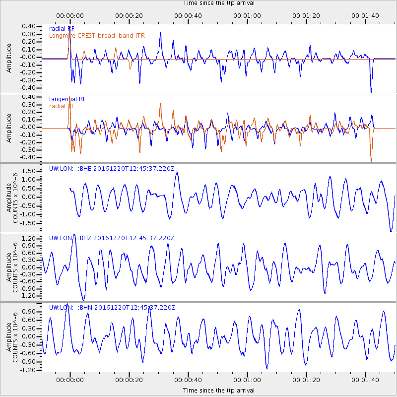
LON Longmire CREST broad-band - Earthquake Result Viewer
*The percent match for this event was below the threshold and hence no stack was calculated.
| Earthquake location: |
Solomon Islands |
| Earthquake latitude/longitude: |
-10.2/160.9 |
| Earthquake time(UTC): |
2016/12/20 (355) 12:33:15 GMT |
| Earthquake Depth: |
12 km |
| Earthquake Magnitude: |
5.9 mb |
| Earthquake Catalog/Contributor: |
NEIC PDE/us |
|
| Network: |
UW Pacific Northwest Regional Seismic Network |
| Station: |
LON Longmire CREST broad-band |
| Lat/Lon: |
46.75 N/121.81 W |
| Elevation: |
853 m |
|
| Distance: |
88.7 deg |
| Az: |
42.134 deg |
| Baz: |
253.856 deg |
| Ray Param: |
$rayparam |
*The percent match for this event was below the threshold and hence was not used in the summary stack. |
|
| Radial Match: |
68.41552 % |
| Radial Bump: |
400 |
| Transverse Match: |
43.6256 % |
| Transverse Bump: |
329 |
| SOD ConfigId: |
11737051 |
| Insert Time: |
2019-04-26 09:58:02.929 +0000 |
| GWidth: |
2.5 |
| Max Bumps: |
400 |
| Tol: |
0.001 |
|
Signal To Noise
| Channel | StoN | STA | LTA |
| UW:LON: :BHZ:20161220T12:45:37.220Z | 1.7799997 | 9.215917E-7 | 5.177482E-7 |
| UW:LON: :BHN:20161220T12:45:37.220Z | 1.5191282 | 5.6234745E-7 | 3.7017776E-7 |
| UW:LON: :BHE:20161220T12:45:37.220Z | 1.01512 | 5.5013504E-7 | 5.419409E-7 |
| Arrivals |
| Ps | |
| PpPs | |
| PsPs/PpSs | |


