You are here: Home > Network List > TA - USArray Transportable Network (new EarthScope stations) Stations List
> Station F26K Sheenjek River, AK, USA > Earthquake Result Viewer
F26K Sheenjek River, AK, USA - Earthquake Result Viewer
*The percent match for this event was below the threshold and hence no stack was calculated.
| Earthquake location: |
Solomon Islands |
| Earthquake latitude/longitude: |
-10.2/160.8 |
| Earthquake time(UTC): |
2016/12/20 (355) 20:07:51 GMT |
| Earthquake Depth: |
3.9 km |
| Earthquake Magnitude: |
5.5 Mwb |
| Earthquake Catalog/Contributor: |
NEIC PDE/us |
|
| Network: |
TA USArray Transportable Network (new EarthScope stations) |
| Station: |
F26K Sheenjek River, AK, USA |
| Lat/Lon: |
67.69 N/144.15 W |
| Elevation: |
683 m |
|
| Distance: |
87.0 deg |
| Az: |
18.266 deg |
| Baz: |
233.937 deg |
| Ray Param: |
$rayparam |
*The percent match for this event was below the threshold and hence was not used in the summary stack. |
|
| Radial Match: |
63.488823 % |
| Radial Bump: |
373 |
| Transverse Match: |
75.28094 % |
| Transverse Bump: |
312 |
| SOD ConfigId: |
11737051 |
| Insert Time: |
2019-04-26 10:03:41.833 +0000 |
| GWidth: |
2.5 |
| Max Bumps: |
400 |
| Tol: |
0.001 |
|
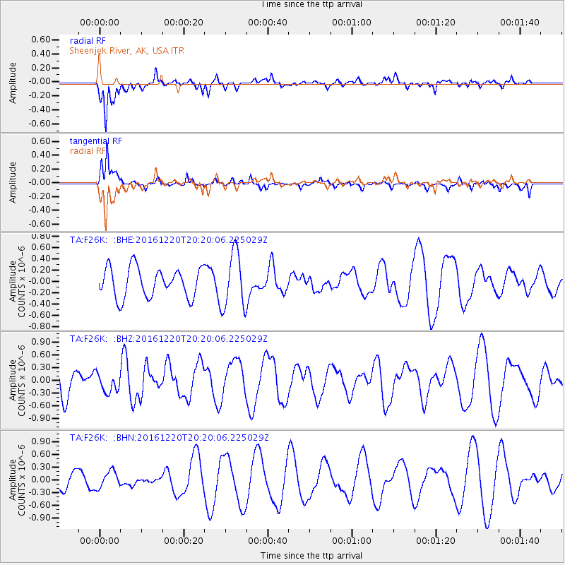
Signal To Noise
| Channel | StoN | STA | LTA |
| TA:F26K: :BHZ:20161220T20:20:06.225029Z | 0.6242362 | 2.1252261E-7 | 3.4045223E-7 |
| TA:F26K: :BHN:20161220T20:20:06.225029Z | 1.1190454 | 2.0057304E-7 | 1.7923585E-7 |
| TA:F26K: :BHE:20161220T20:20:06.225029Z | 1.9196029 | 5.0031883E-7 | 2.6063663E-7 |
| Arrivals |
| Ps | |
| PpPs | |
| PsPs/PpSs | |


