You are here: Home > Network List > CB - China National Seismic Network Stations List
> Station GYA Guiyang,Yunnan Province > Earthquake Result Viewer
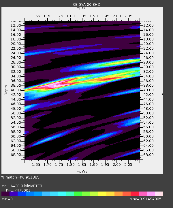
GYA Guiyang,Yunnan Province - Earthquake Result Viewer
| Earthquake location: |
Banda Sea |
| Earthquake latitude/longitude: |
-7.5/127.9 |
| Earthquake time(UTC): |
2016/12/21 (356) 00:17:15 GMT |
| Earthquake Depth: |
152 km |
| Earthquake Magnitude: |
6.7 Mww |
| Earthquake Catalog/Contributor: |
NEIC PDE/us |
|
| Network: |
CB China National Seismic Network |
| Station: |
GYA Guiyang,Yunnan Province |
| Lat/Lon: |
26.46 N/106.66 E |
| Elevation: |
1162 m |
|
| Distance: |
39.5 deg |
| Az: |
329.387 deg |
| Baz: |
145.718 deg |
| Ray Param: |
0.07437732 |
| Estimated Moho Depth: |
38.0 km |
| Estimated Crust Vp/Vs: |
1.75 |
| Assumed Crust Vp: |
6.113 km/s |
| Estimated Crust Vs: |
3.498 km/s |
| Estimated Crust Poisson's Ratio: |
0.26 |
|
| Radial Match: |
90.931885 % |
| Radial Bump: |
400 |
| Transverse Match: |
81.17505 % |
| Transverse Bump: |
400 |
| SOD ConfigId: |
11737051 |
| Insert Time: |
2019-04-26 10:07:10.802 +0000 |
| GWidth: |
2.5 |
| Max Bumps: |
400 |
| Tol: |
0.001 |
|

Signal To Noise
| Channel | StoN | STA | LTA |
| CB:GYA:00:BHZ:20161221T00:24:00.879996Z | 36.165455 | 4.921302E-6 | 1.3607743E-7 |
| CB:GYA:00:BHN:20161221T00:24:00.879996Z | 28.32953 | 2.1887906E-6 | 7.72618E-8 |
| CB:GYA:00:BHE:20161221T00:24:00.879996Z | 11.506619 | 1.4367969E-6 | 1.2486699E-7 |
| Arrivals |
| Ps | 5.0 SECOND |
| PpPs | 16 SECOND |
| PsPs/PpSs | 21 SECOND |


