You are here: Home > Network List > CB - China National Seismic Network Stations List
> Station HEH Heihe,Heilongjiang Province > Earthquake Result Viewer
HEH Heihe,Heilongjiang Province - Earthquake Result Viewer
| Earthquake location: |
Banda Sea |
| Earthquake latitude/longitude: |
-7.5/127.9 |
| Earthquake time(UTC): |
2016/12/21 (356) 00:17:15 GMT |
| Earthquake Depth: |
152 km |
| Earthquake Magnitude: |
6.7 Mww |
| Earthquake Catalog/Contributor: |
NEIC PDE/us |
|
| Network: |
CB China National Seismic Network |
| Station: |
HEH Heihe,Heilongjiang Province |
| Lat/Lon: |
50.25 N/127.41 E |
| Elevation: |
165 m |
|
| Distance: |
57.5 deg |
| Az: |
359.651 deg |
| Baz: |
179.461 deg |
| Ray Param: |
0.06295841 |
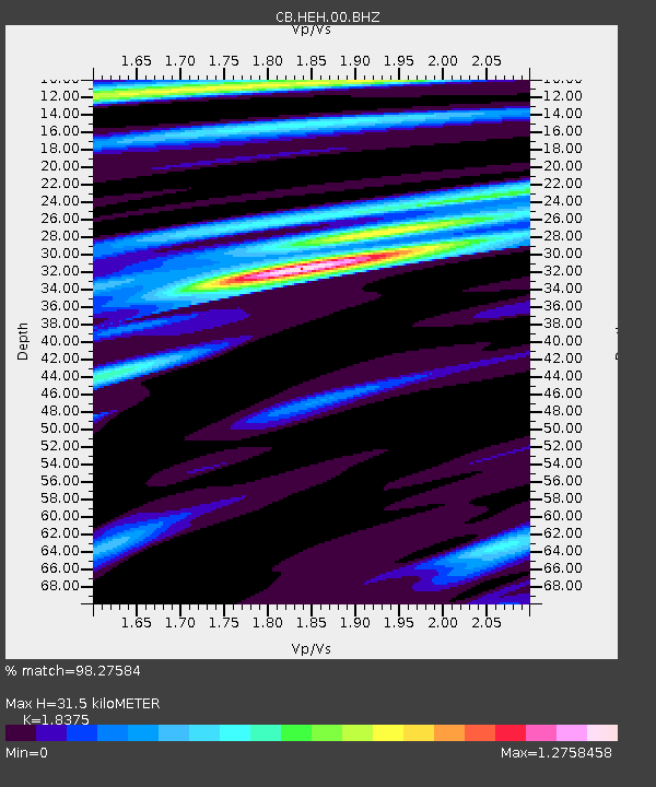
| Estimated Moho Depth: |
31.5 km |
| Estimated Crust Vp/Vs: |
1.84 |
| Assumed Crust Vp: |
6.419 km/s |
| Estimated Crust Vs: |
3.493 km/s |
| Estimated Crust Poisson's Ratio: |
0.29 |
|
| Radial Match: |
98.27584 % |
| Radial Bump: |
198 |
| Transverse Match: |
90.2481 % |
| Transverse Bump: |
400 |
| SOD ConfigId: |
11737051 |
| Insert Time: |
2019-04-26 10:07:14.773 +0000 |
| GWidth: |
2.5 |
| Max Bumps: |
400 |
| Tol: |
0.001 |
|
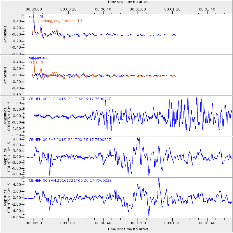
Signal To Noise
| Channel | StoN | STA | LTA |
| CB:HEH:00:BHZ:20161221T00:26:17.750022Z | 23.88237 | 2.7009733E-6 | 1.1309486E-7 |
| CB:HEH:00:BHN:20161221T00:26:17.750022Z | 13.9301195 | 1.1183541E-6 | 8.028317E-8 |
| CB:HEH:00:BHE:20161221T00:26:17.750022Z | 2.3838255 | 1.8446285E-7 | 7.738102E-8 |
| Arrivals |
| Ps | 4.3 SECOND |
| PpPs | 13 SECOND |
| PsPs/PpSs | 18 SECOND |


