You are here: Home > Network List > KC - Central Asian Seismic Network of CAIAG Stations List
> Station TARG Taragai, Kyrgyzstan > Earthquake Result Viewer
TARG Taragai, Kyrgyzstan - Earthquake Result Viewer
| Earthquake location: |
Banda Sea |
| Earthquake latitude/longitude: |
-7.5/127.9 |
| Earthquake time(UTC): |
2016/12/21 (356) 00:17:15 GMT |
| Earthquake Depth: |
152 km |
| Earthquake Magnitude: |
6.7 Mww |
| Earthquake Catalog/Contributor: |
NEIC PDE/us |
|
| Network: |
KC Central Asian Seismic Network of CAIAG |
| Station: |
TARG Taragai, Kyrgyzstan |
| Lat/Lon: |
41.73 N/77.80 E |
| Elevation: |
3530 m |
|
| Distance: |
67.0 deg |
| Az: |
321.437 deg |
| Baz: |
124.335 deg |
| Ray Param: |
0.05680497 |
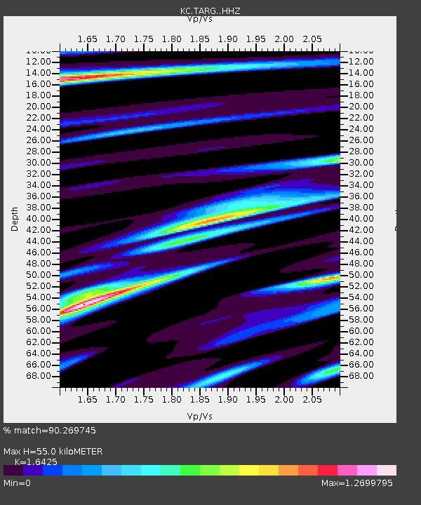
| Estimated Moho Depth: |
55.0 km |
| Estimated Crust Vp/Vs: |
1.64 |
| Assumed Crust Vp: |
6.491 km/s |
| Estimated Crust Vs: |
3.952 km/s |
| Estimated Crust Poisson's Ratio: |
0.21 |
|
| Radial Match: |
90.269745 % |
| Radial Bump: |
400 |
| Transverse Match: |
88.50192 % |
| Transverse Bump: |
400 |
| SOD ConfigId: |
11737051 |
| Insert Time: |
2019-04-26 10:07:59.754 +0000 |
| GWidth: |
2.5 |
| Max Bumps: |
400 |
| Tol: |
0.001 |
|

Signal To Noise
| Channel | StoN | STA | LTA |
| KC:TARG: :HHZ:20161221T00:27:20.990012Z | 11.191344 | 3.2000098E-6 | 2.8593612E-7 |
| KC:TARG: :HHN:20161221T00:27:20.990012Z | 2.2766733 | 3.456956E-7 | 1.5184243E-7 |
| KC:TARG: :HHE:20161221T00:27:20.990012Z | 7.8436384 | 1.2351672E-6 | 1.5747376E-7 |
| Arrivals |
| Ps | 5.7 SECOND |
| PpPs | 21 SECOND |
| PsPs/PpSs | 27 SECOND |


