You are here: Home > Network List > PS - Pacific21 Stations List
> Station PSI Parapat, Indonesia > Earthquake Result Viewer
PSI Parapat, Indonesia - Earthquake Result Viewer
| Earthquake location: |
Banda Sea |
| Earthquake latitude/longitude: |
-7.5/127.9 |
| Earthquake time(UTC): |
2016/12/21 (356) 00:17:15 GMT |
| Earthquake Depth: |
152 km |
| Earthquake Magnitude: |
6.7 Mww |
| Earthquake Catalog/Contributor: |
NEIC PDE/us |
|
| Network: |
PS Pacific21 |
| Station: |
PSI Parapat, Indonesia |
| Lat/Lon: |
2.69 N/98.92 E |
| Elevation: |
987 m |
|
| Distance: |
30.6 deg |
| Az: |
288.293 deg |
| Baz: |
109.533 deg |
| Ray Param: |
0.078992255 |
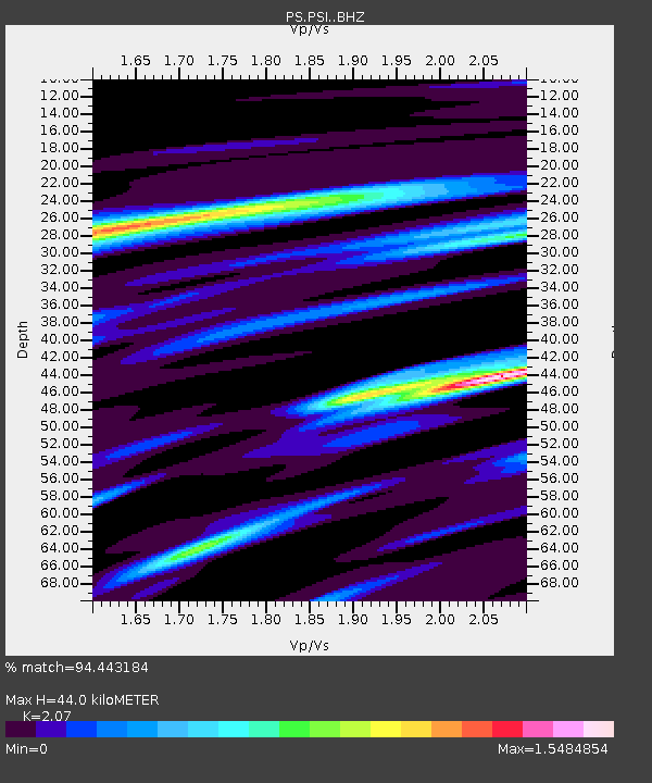
| Estimated Moho Depth: |
44.0 km |
| Estimated Crust Vp/Vs: |
2.07 |
| Assumed Crust Vp: |
6.468 km/s |
| Estimated Crust Vs: |
3.125 km/s |
| Estimated Crust Poisson's Ratio: |
0.35 |
|
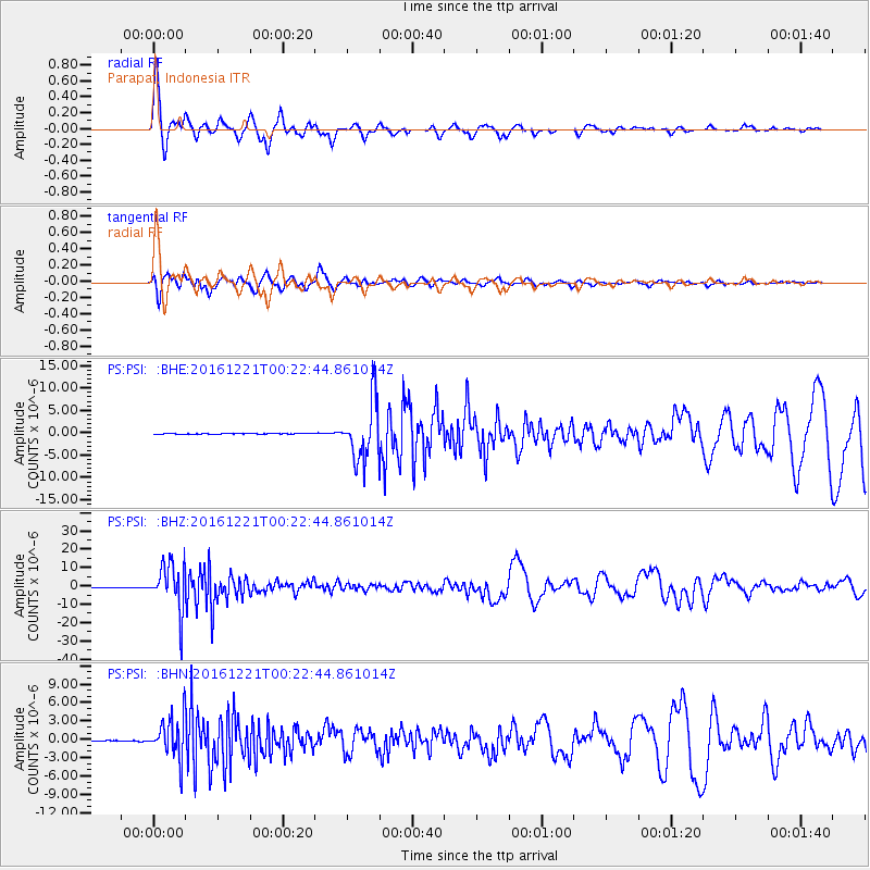
| Radial Match: |
94.443184 % |
| Radial Bump: |
363 |
| Transverse Match: |
91.83112 % |
| Transverse Bump: |
400 |
| SOD ConfigId: |
11737051 |
| Insert Time: |
2019-04-26 10:08:28.801 +0000 |
| GWidth: |
2.5 |
| Max Bumps: |
400 |
| Tol: |
0.001 |
|
Signal To Noise
| Channel | StoN | STA | LTA |
| PS:PSI: :BHZ:20161221T00:22:44.861014Z | 142.00227 | 1.28614465E-5 | 9.0572115E-8 |
| PS:PSI: :BHN:20161221T00:22:44.861014Z | 57.298008 | 3.456082E-6 | 6.031767E-8 |
| PS:PSI: :BHE:20161221T00:22:44.861014Z | 82.15113 | 6.4011165E-6 | 7.791879E-8 |
| Arrivals |
| Ps | 7.8 SECOND |
| PpPs | 19 SECOND |
| PsPs/PpSs | 27 SECOND |


