You are here: Home > Network List > S - Seismographs in Schools Projects Stations List
> Station AUMHS Melrose High School, ACT > Earthquake Result Viewer
AUMHS Melrose High School, ACT - Earthquake Result Viewer
| Earthquake location: |
Banda Sea |
| Earthquake latitude/longitude: |
-7.5/127.9 |
| Earthquake time(UTC): |
2016/12/21 (356) 00:17:15 GMT |
| Earthquake Depth: |
152 km |
| Earthquake Magnitude: |
6.7 Mww |
| Earthquake Catalog/Contributor: |
NEIC PDE/us |
|
| Network: |
S Seismographs in Schools Projects |
| Station: |
AUMHS Melrose High School, ACT |
| Lat/Lon: |
35.36 S/149.09 E |
| Elevation: |
615 m |
|
| Distance: |
33.9 deg |
| Az: |
147.94 deg |
| Baz: |
319.914 deg |
| Ray Param: |
0.07751898 |
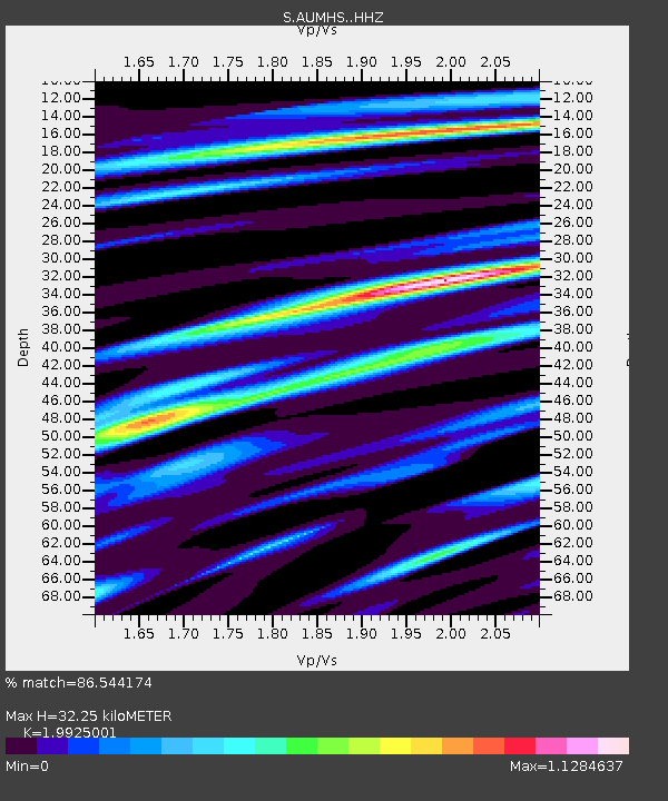
| Estimated Moho Depth: |
32.25 km |
| Estimated Crust Vp/Vs: |
1.99 |
| Assumed Crust Vp: |
6.633 km/s |
| Estimated Crust Vs: |
3.329 km/s |
| Estimated Crust Poisson's Ratio: |
0.33 |
|
| Radial Match: |
86.544174 % |
| Radial Bump: |
400 |
| Transverse Match: |
55.93443 % |
| Transverse Bump: |
400 |
| SOD ConfigId: |
11737051 |
| Insert Time: |
2019-04-26 10:08:35.375 +0000 |
| GWidth: |
2.5 |
| Max Bumps: |
400 |
| Tol: |
0.001 |
|

Signal To Noise
| Channel | StoN | STA | LTA |
| S:AUMHS: :HHZ:20161221T00:23:12.589988Z | 4.273995 | 3.5383982E-6 | 8.278902E-7 |
| S:AUMHS: :HHN:20161221T00:23:12.589988Z | 4.1921635 | 1.6375515E-6 | 3.9062203E-7 |
| S:AUMHS: :HHE:20161221T00:23:12.589988Z | 1.010291 | 1.292025E-6 | 1.2788643E-6 |
| Arrivals |
| Ps | 5.2 SECOND |
| PpPs | 14 SECOND |
| PsPs/PpSs | 19 SECOND |


