You are here: Home > Network List > S - Seismographs in Schools Projects Stations List
> Station AUMTC Mt Clear College/Earth Ed, VIC, Australia > Earthquake Result Viewer
AUMTC Mt Clear College/Earth Ed, VIC, Australia - Earthquake Result Viewer
| Earthquake location: |
Banda Sea |
| Earthquake latitude/longitude: |
-7.5/127.9 |
| Earthquake time(UTC): |
2016/12/21 (356) 00:17:15 GMT |
| Earthquake Depth: |
152 km |
| Earthquake Magnitude: |
6.7 Mww |
| Earthquake Catalog/Contributor: |
NEIC PDE/us |
|
| Network: |
S Seismographs in Schools Projects |
| Station: |
AUMTC Mt Clear College/Earth Ed, VIC, Australia |
| Lat/Lon: |
37.61 S/143.88 E |
| Elevation: |
49 m |
|
| Distance: |
33.3 deg |
| Az: |
156.487 deg |
| Baz: |
330.126 deg |
| Ray Param: |
0.0778105 |
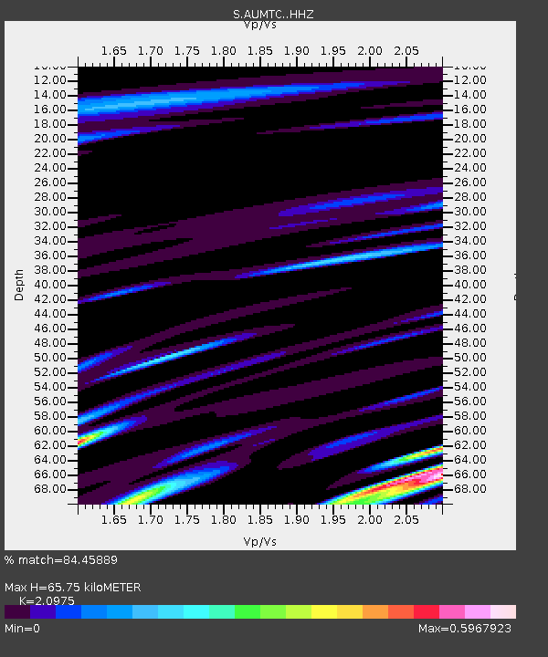
| Estimated Moho Depth: |
65.75 km |
| Estimated Crust Vp/Vs: |
2.10 |
| Assumed Crust Vp: |
6.577 km/s |
| Estimated Crust Vs: |
3.136 km/s |
| Estimated Crust Poisson's Ratio: |
0.35 |
|
| Radial Match: |
84.45889 % |
| Radial Bump: |
400 |
| Transverse Match: |
64.07784 % |
| Transverse Bump: |
400 |
| SOD ConfigId: |
11737051 |
| Insert Time: |
2019-04-26 10:08:35.753 +0000 |
| GWidth: |
2.5 |
| Max Bumps: |
400 |
| Tol: |
0.001 |
|

Signal To Noise
| Channel | StoN | STA | LTA |
| S:AUMTC: :HHZ:20161221T00:23:07.700004Z | 5.0104747 | 3.2034773E-6 | 6.39356E-7 |
| S:AUMTC: :HHN:20161221T00:23:07.700004Z | 3.9858801 | 2.2960267E-6 | 5.7604007E-7 |
| S:AUMTC: :HHE:20161221T00:23:07.700004Z | 1.3846415 | 6.549957E-7 | 4.7304349E-7 |
| Arrivals |
| Ps | 12 SECOND |
| PpPs | 29 SECOND |
| PsPs/PpSs | 41 SECOND |


